Showing posts with label Water Quality. Show all posts

Tuesday, April 12, 2016

InfoSWMM Sustain Generation V2.0 Delivers Significant Advancements for Comprehensive Urban Stormwater Treatment and Analysis

InfoSWMM Sustain Generation V2.0 Delivers Significant Advancements for Comprehensive Urban Stormwater Treatment and Analysis

Latest Release Confirms Product’s Role as Industry Leading GIS-Centric Solution for Determining Optimal Green Infrastructure Strategies

Broomfield, Colorado, USA, April 12, 2016

Innovyze, a leading global innovator of business analytics software and technologies for smart wet infrastructure, today announced  worldwide availability of the V2.0 Generation of its industry-leading InfoSWMM Sustain for comprehensive urban stormwater treatment and analysis. The new version lets users quickly and reliably determine optimal green infrastructure strategies for reducing volume and peak flows to combined sewer systems as well as evaluating the benefits of distributed green infrastructure implementation on water quantity and quality in urban streams.

InfoSWMM Sustain is a comprehensive geocentric decision support system created to assist stormwater management professionals in developing and implementing plans for flow and pollution control measures to protect source waters and meet water quality goals. The software allows users to locate, develop, evaluate, and select optimal best management practice (BMP), low impact development (LID) and Sustainable Urban Drainage Systems (SUDS) combinations at various watershed scales based on cost and effectiveness. It can accurately model any combination of LID controls, such as porous permeable pavement, rain gardens, green roofs, street planters, rain barrels, infiltration trenches and vegetative swales to determine their effectiveness in managing stormwater and combined sewer overflows. Furthermore, InfoSWMM Sustain will automatically assess the geographic properties in the study area including soil properties, land use, slope, building footprint, groundwater, land ownership, imperviousness and other pertinent factors to determine all possible locations of feasible green infrastructure alternatives. These expanded capabilities can greatly assist users in developing cost-effective and reliable implementation plans for flow and pollution control aimed at protecting source waters and meeting water quality goals. They do so by helping users answer key questions: How effective are BMPs in reducing runoff and pollutant loadings? What are the most cost-effective solutions for meeting water quality and quantity objectives? Where, what type, and how extensive should BMPs be?

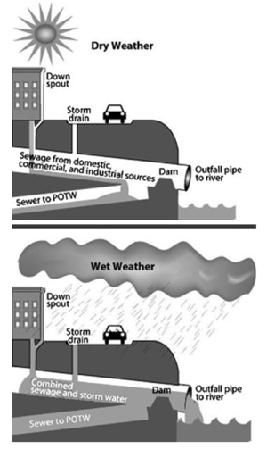
By seamlessly integrating ArcGIS 10.x (Esri, Redlands, CA) with SWMM 5.1, InfoSWMM Sustain greatly expands and improves on the USEPA SUSTAIN software to provide critically needed support to watershed practitioners at all levels in developing stormwater management evaluations and cost optimizations to meet their program needs. The software can automatically import any SWMM 5.1, InfoSWMM or InfoWorks ICM (exported to SWMM 5.1) model, then evaluate numerous potential combinations of BMPs and LIDs to determine the optimal combination to meet specified objectives such as runoff volume or pollutant loading reductions. Both kinematic wave and full dynamic wave flow routing models are fully supported. Among its many vital applications, InfoSWMM Sustain can be effectively used in developing TMDL implementation plans, identifying management practices to achieve pollutant reductions under a separate municipal storm sewer system (MS4) stormwater permit, determining optimal green infrastructure strategies for reducing volume and peak flows to combined sewer systems, evaluating the benefits of distributed green infrastructure implementation on water quantity and quality in urban streams, and developing a phased BMP installation plan using cost effectiveness curves.

Among its many major enhancements, Version 2.0 lets users optimize the entire system (using advanced Genetic Algorithms), not only individual subcatchments. Users can also choose a system-wide budget constraint and reduction target for runoff and/or pollution, view LID design and performance directly from the Cost Effectiveness Curve, compare hydrographs for runoff and pollutant of the various solutions on the Cost Effectiveness Curve, implement any desired LID design solution in InfoSWMM, and display the optimal system-wide runoff/pollutant reduction. The new release also introduces an improved, more intuitive user interface that visually highlights and simplifies the workflow process. Users can now quickly evaluate complex decisions about green infrastructure selection and placement performance, costs for meeting flow or water quality targets, or both. The software gives them the power they need to maximize water quality benefits, minimize stormwater management costs and combined sewer overflows, and protect the environment and public health.

“With InfoSWMM Sustain, we are extending our success in the smart network modeling marketplace to address the specific needs of stormwater management professionals and their engineering consultants,” said Paul F. Boulos, Ph.D., BCEEM, Hon.D.WRE, Dist.D.NE, Dist.M.ASCE, NAE, President, COO and Chief Technical Officer of Innovyze. “The new release performs very sophisticated hydrologic and water quality modeling in watersheds and urban streams, and enables users to determine optimal management solutions at multiple-scale watersheds to achieve desired water quality objectives based on cost effectiveness. It also gives users the power tool they need to maximize water quality benefits, minimize stormwater management costs and combined sewer overflows, and protect the environment and public health. This is a must-have for predicting the environmental outcomes of different design and management approaches as well as developing optimal plans for flow and pollution control to protect source waters and meet water quality goals.”

Pricing and Availability 
Upgrade to InfoSWMM Sustain V2.0 is now available worldwide by subscription. Subscription members can immediately download the new version free of charge directly from www.innovyze.com. The Innovyze Subscription Program is a friendly customer support and software maintenance program that ensures the longevity and usefulness of Innovyze products. It gives subscribers instant access to new functionality as it is developed, along with automatic software updates and upgrades. For the latest information on the Innovyze Subscription Program, visit www.innovyze.com or contact your local Innovyze Channel Partner.
About InnovyzeInnovyze is a leading global provider of wet infrastructure business analytics software solutions designed to meet the technological needs of water/wastewater utilities, government agencies, and engineering organizations worldwide. Its clients include the majority of the largest UK, Australasian, East Asian and North American cities, foremost utilities on all five continents, and ENR top-rated design firms. With unparalleled expertise and offices in North America, Europe and Asia Pacific, the Innovyze connected portfolio of best-in-class product lines empowers thousands of engineers to competitively plan, manage, design, protect, operate and sustain highly efficient and reliable infrastructure systems, and provides an enduring platform for customer success. For more information, call Innovyze at +1 626-568-6868, or visit www.innovyze.com.
Innovyze Contact:Rajan RayDirector of Marketing and Client Service Manager
Rajan.Ray@innovyze.com
+1 626-568-6868
- See more at: http://www.innovyze.com/news/1672/#sthash.BhyC5GxG.dpuf

Monday, February 29, 2016

Infosessie nieuwste trends & tools drinkwater producten Innovyze #INFOWATER

Infosessie nieuwste trends & tools drinkwater producten Innovyze  

“SCADAWatch equips us with real-time operational and predictive analytics” Analytics that help us make faster and more confident decisions for optimal performance of our water distribution system. They give us a comprehensive view into the performance of our water systems and enable us to improve operational decisions and better manage risks with information to make decisions about asset renewal and rehabilitation. As a component of the District’s Asset Management Plan, SCADAWatch is envisioned to reduce cost to customers while maintaining required customer service levels."

“InfoWater is a critical component of our Twenty-Year Master Plan” The software’s comprehensive hydraulic and water quality modeling and simulation capabilities and its seamless GIS integration will help us improve our water system efficiency and performance, and ensure that we continue to best serve our customers."

Monday, December 21, 2015

Job Posting - Sediment and Water Quality Transport in Urban Watersheds Research Participation Program Office of Research and Development National Risk Management Research Laboratory U.S. Environmental Protection Agency (EPA)

Sediment and Water Quality Transport in Urban Watersheds
Research Participation Program
Office of Research and Development
National Risk Management Research Laboratory
U.S. Environmental Protection Agency (EPA)

EPA-ORD/NRMRL-WSWRD-2015-04

Project Description:


Extra Note: Water resources job opening with in Cincinnati, Ohio for someone with a masters or PhD:
A postgraduate research project training opportunity is currently available at the U.S. Environmental Protection Agency’s (EPA), Office of Research and Development (ORD)/National Risk Management Research Laboratory (NRMRL). The appointment will be served with the Water Supply and Water Resources Division (WSWRD) in Cincinnati, Ohio. 
The WSWRD conducts research on microbial contaminants, water treatment technology, urban water management, and water quality controls for the benefit of the nation. 
The research opportunity will include activities such as:
  • Formulation of numerical techniques for simulation of nutrient and sediment water quality transport.
  • Development of initial solution prototype.
  • Testing of prototype with analytical, synthetic, and field study data.
  • Development of production code for SWMM based on prototype experience
  • Preparation of research products documenting methodology and results. 
The research participant will gain:
  • Experience with numerical solution of advection-diffusion-reaction equations
  • Knowledge of overland flow hydrology and numerical simulation of open channel flow hydraulics
  • Experience with object oriented software design
  • Experience developing software in C/C++.

Qualifications:

Applicants must have received a master’s or doctoral degree in civil/environmental engineering, hydrology, environmental science, or other related discipline within five years of the desired starting date, or completion of all requirements for the degree should be expected prior to the starting date.
The program is open to all qualified individuals without regard to race, sex, religion, color, age, physical or mental disability, national origin, or status as a Vietnam era or disabled veteran. U.S. citizenship or lawful permanent resident status is preferred (but a candidate also may hold an appropriate visa status; an H1B visa is not appropriate). Guidelines for non-U.S. citizens may be found at http://orise.orau.gov/epa/applicants/immigration.htm. 
The appointment is full time for one year and may be renewed upon recommendation of EPA and contingent on the availability of funds. The participant will receive a monthly stipend. Funding may be made available to reimburse the participant's travel expenses to present the results of his/her research at scientific conferences. No funding will be made available to cover travel costs for pre-appointment visits, relocation costs, tuition and fees, or a participant's health insurance. The participant must show proof of health and medical insurance. The participant does not become an EPA employee.

Technical Questions:

The mentor for this project is Michael Tryby (tryby.michael@epa.gov). 

How to Apply:

An application can be found at http://orise.orau.gov/epa/applicants/application.htmPlease reference Project # EPA-ORD/NRMRL-WSWRD-2015-04 when calling or writing for information.

Tuesday, October 13, 2015

Innovyze Releases InfoWater Generation V12 With Advanced Pipe Break Break and Leakage Modeling

Innovyze Releases InfoWater Generation V12 With Advanced Pipe Break Break and Leakage Modeling

New Release Provides Mission-Critical Functionality For Proactive Management of Water Distribution Systems

Broomfield, Colorado, USA, October 13, 2015

In its ongoing quest to equip the global water industry with the world’s most powerful and comprehensive GIS-centric infrastructure modeling and management solutions, Innovyze, a leading global innovator of business analytics software and technologies for smart wet infrastructure, today announced the worldwide availability of the V12 Generation of InfoWater for ArcGIS (Esri, Redlands, CA). The release forcefully exemplifies  Innovyze’s strong commitment to meeting the requirements of its user base and the increasing demands of the global water industry.

Globally, water demand is rising, aging water infrastructures are rapidly deteriorating, and the impact of water main breaks and leakage is relentless. In the U.S. alone, drinking water systems maintain more than two million miles of distribution mains with about 237,600 water main breaks occurring every year. An estimated seven billion gallons of clean drinking water are wasted every day — a staggering 2.6 trillion gallons annually.

With this new version, Innovyze has further refined the superb water supply and distribution modeling and analysis features that have helped make InfoWater a leading choice among the world’s top water utilities and engineering firms. The award-winning software has long been renowned for its extreme performance and comprehensive toolsets and extensions. Now by enabling users to explicitly model water main breaks (and leaks), they can develop effective leakage reduction and control and demand and maintenance management strategies to maximize the quantity of revenue-producing water, ensure hydraulic and water integrity, improve the quality of service, and conserve this precious resource. Breaks can be specified for any pipe in the network along with their location, size, and time of occurrence. Small breaks can also be automatically distributed at the two end nodes of a pipe. InfoWater will then compute and report the total water volume lost to breaks and leaks for any user-specified period. It will also report their impact on the hydraulic (e.g., flows, pressures, velocities, and fire-fighting capacity) and water quality (e.g., chlorine concentrations) integrity of the water distribution system.

Built atop ArcGIS, InfoWater seamlessly integrates sophisticated predictive analytics, systems dynamics and optimization functionality directly within the powerful ArcGIS setting. From fire flow and dynamic water quality simulations, valve criticality and energy cost analysis to pressure zone management and advanced Genetic Algorithm and Particle Swarm optimization, the suite comes equipped with everything water utility owner-operators need to best plan, design, operate, secure and sustain their distribution systems.

The software also serves as a base platform for advanced smart network modeling, operation, capital planning and asset management extensions. Among these critical applications are IWLive (real-time operations and security); InfoWater UDF (unidirectional flushing);CapPlan (risk-based capital planning); InfoMaster and InfoMaster Mobile (asset integrity management and condition assessment);InfoWater MSX (multi-species, temperature, and particle transport/deposition modeling); InfoWater BTX (event/particle backtracking);InfoSurge (surge/transient analysis); Sustainability (carbon footprint calculation); BalanceNet (real-time energy management and operations optimization); PressureWatch (real-time network hydraulic integrity monitoring); QualWatch (real-time network water quality integrity monitoring); SCADAWatch (real-time business intelligence and performance monitoring); DemandWatch (water demand forecasting); and DemandAnalyst (real-time water demand and diurnal pattern estimations).

These advancements propel the InfoWater family of solutions into the next generation, furthering Innovyze’s time-honored practice of continually adding critical value to its software and bringing unsurpassed modeling and design capabilities into the mainstream. The suite has the robustness and feature set needed to handle the most demanding analyses. Yet it’s intuitive enough for new users to master without a drawn-out learning curve, making it the ultimate GIS-centric decision support tool for water supply and distribution systems. Like all Innovyze products, InfoWater V12 is backed by unparalleled high-touch technical support. For an even faster return on investment, organizations may opt to call on Innovyze Implementation Services to accelerate deployment, integration and implementation of best modeling practices.

“At Innovyze, we give our customers the fast, accurate and reliable simulation they need to predict real-world water infrastructure performance,” said Paul F. Boulos, Ph.D., BCEEM, Hon.D.WRE, Dist.D.NE, Dist.M.ASCE, NAE, the company’s President, COO and Chief Technical Officer. “Our new release makes it easy for engineers to quickly analyze, design and operate increasingly large and complex water distribution networks and derive solutions that help them achieve their most critical business goals. Specifically, it will help them minimize economic losses, ensure safety and control environmental problems. Our superior smart water network modeling and management solutions suite provides water operators and engineers the ultimate decision support tool for optimal results.”

Friday, September 18, 2015

Some of today’s sewers were built before bathrooms as we know them existed. It’s time to upgrade. From City Lab cites Wayne Huber

Flushing the Toilet Has Never Been Riskier


Amit Dave / REUTERS

Flushing toilets enable most Americans to make their own waste disappear as if by magic, but most would be hard-pressed to answer this simple question: When you flush, where does it go?
Septic tank owners, about 20 percent of Americans, are most likely to be able to give an accurate answer, because they’re responsible for the maintenance of their own sewage-disposal systems. A flush from one of their toilets sends wastewater to a tank buried on their property, where the waste products separate into solid and liquid layers and partially decompose. The liquid layer flows out of the tank and into a drainfield that disperses it into the soil, wherenaturally occurring microbes remove harmful bacteria, viruses, and nutrients. The solid layer stays behind in the form of sludge that must be pumped out periodically as part of routine maintenance. If the tank is properly designed and maintained, those bacteria, viruses, and nutrients stay out of groundwater and surface water that people may use for drinking water, and they never reach surface water bodies where people swim or boat.
The vast majority of the 80 percent of Americans who don’t use septic tanks are served by municipal water-treatment plants. Waste from their homes is whisked immediately off the premises, never to be seen, smelled, or considered again. Pipes carry waste from these homes to wastewater-treatment plants that, in some ways, work like a septic tank on a very large scale.
Just as in a septic tank, the solid and liquid wastes are separated first in a process known as primary treatment. Next, as in a septic tank’s drainfield, bacteria break down contaminants in a process called secondary treatment. After that, treatment with chlorine kills the remaining bacteria. Then, in some communities, special treatment technologies remove contaminants that are of special concern, such as phosphorus or nitrogen. When the process is complete, the treated waste meets regulatory standards and is released to a nearby water body—that is, if all goes well. If all doesn’t go well—perhaps the treatment plant suffers an outage or there’s more waste than the plant was designed to treat—untreated waste can be released to surface water.


As treatment plants age across the United States and as the country’s population grows, these releases are becoming more problematic, contributing to the serious surface-water problems that crop up frequently in the news. Harmful algal blooms like the one that cost Toledo, Ohio, its drinking waterlast summer, fish kills like the one recently reported off Long Island, and the much-discussed dead zone in the Gulf of Mexico are all fed by phosphorus, nitrogen, and other contaminants found in the untreated sewage that, according to EPA estimates, flows out of America’s treatment plants during the23,000 to 75,000 sanitary-sewer overflows that happen per year.
The causes of these water-quality issues are complex, because the same pollutants can be washed into surface water from agricultural land, industrial sites, and fertilized lawns dotted with pet waste, but the 3 to 10 billion gallons of untreated waste released from our sewage-treatment plants per year cannot help but have an impact.Specifically, they affect the water you swim in and the water you drink.
* * *
A number of studies, including this one from 2010, have found that emergency room visits for gastrointestinal distress increase after a heavy rain. These illnesses are believed to spike after a storm because rainwater washes pathogens into lakes and rivers used for recreation and drinking water. A 2015 study published in Environmental Health Perspectives goes a step further than earlier research by pointing to a common type of municipal sewage-treatment system, combined-sewer systems, as an important factor in these illnesses.
The EPA has called overflows from combined sewer systems “the largest category of our Nation’s wastewater infrastructure that still need to be addressed,” affecting Americans in 32 states, including the District of Columbia. The agency has been working with municipal water systems to address the problem for decades and much progress has been made, but to understand why it’s taking so long, you have to consider history. You also have to consider the massive costs that come with making changes to public works that have served millions of people for more than a century.
Combined sewers collect human waste, industrial waste, and stormwater runoff into a single pipe for treatment and disposal. (In other municipalities, these waste streams are handled separately.) In dry weather, a combined sewer ordinarily carries a relatively low volume of waste, delivering it to publicly owned treatment works, or POTWs for short, that are designed to handle that flow. In plain terms, when a combined sewer system is functioning properly, you can generally trust that when you flush, the contents of the toilet bowl end up where they’re supposed to go.


USEPA
Things change when it rains in communities served by combined sewers. Because a combined system must handle surges of stormwater, rainfall markedly increases the volume of waste that its equipment must handle, making this type of sewage system particularly likely to overflow into surface water. As these diagramsshow, they were designed to do this as a fail-safe for system failures that were intended to be rare but aren’t any longer. If you’re accustomed to a faint smell of sewage in the streets after a rainstorm, these diagrams will show you why.
Unfortunately, the receiving waters for these rain-induced spills are sometimes the same water bodies that are used for drinking water, and sometimes people swim there, too. And sometimes the overflow is so significant that the stormwater-and-sewage mixture backs up into the streets where people walk.
Is it any wonder that rainy weather often triggers a spike in stomach bugs and beach closures?
* * *
Given what’s at stake, why are upgrades to aging systems taking so long? Consider this map of the 772 American communities with combined-sewer systems.
Most combined systems are concentrated in the older cities of the Northeast and the Great Lakes region, but they also exist in other older cities as far-flung as Atlanta, Memphis, and San Francisco. In other words, the systems that pose risks today happen to be the ones—state-of-the-art when they were built, but not today—that are in some of the biggest cities in America, which have acombined population of approximately 40 million people.


If you’re feeling relieved to see that your hometown isn’t marked on the map, remember that fecal-coliform bacteria don’t always stay close to home. Waste spilled into the Ohio River affects everyone down the Ohio and the Mississippi, and it contributes to the ongoing woes of the Gulf of Mexico. Even if you don’t live in the Northeast, along the Ohio, in the Great Lakes region, along the Mississippi, or on the Gulf Coast, bear in mind that 40 percent of the commercial seafood caught in the continental U.S. comes from the Gulf of Mexico. In other words, when Cincinnati’s sewer system overflows into the Ohio, it intrudes into the food chain of a lot of people.
* * *
The EPA calls combined sewers “remnants of the country's early infrastructure.”The first sewers weren’t designed to handle the constant and huge stream of wastes from our toilets, because they were invented when we didn’t have any toilets. Sewers were originally built to solve the problems of cities that were flooded with their own refuse—garbage, animal manure, and human waste left in the open rather than in a privy or latrine—during every rainstorm. To prevent that flooding, the fouled stormwater was shunted out of town and into the nearest handy receptacle, which was often a lake, river, stream, or ocean.
When flush toilets became common in the mid-1800s, they were piped into these existing sewers, introducing much more human waste, as well as a large volume of water that had never been there before. In some ways, this was a design feature, not a bug, because the burst of stormwater flushed out pipes that might have otherwise gotten clogged. This flush of rainwater also diluted the waste before it hit a nearby river.
In time, though, dilution wasn’t enough to keep waterways safe and attractive, and sewage treatment plants were invented to clean up the waste stream before releasing it to water bodies. Newer cities, which were starting from scratch, generally handled stormwater separately from human and industrial wastes from the start, but cities whose sewer systems had always been combined continued to treat both waste streams together.


As the older cities grew larger, their combined-treatment systems struggled to keep up, and growing populations weren’t the only factor. Time itself exacerbated their woes. In Hoboken, for example, some sewer lines date back to the Civil War. Common sense says that pipes that have been buried for a century and a half tend to leak. Over time, they also get clogged with debris or even congealed cooking oil, resulting in narrowed pipes that overflow even more easily.
When narrowed pipes are already overloaded, the added influx of stormwater when it rains becomes just too much water. Now, some cities experience overflows with less than a quarter-inch of rain, with resulting risks to human health. It is common for cities with combined-sewer systems to advise citizens to stay out of the water for days after any rainfall. And now the Environmental Health Perspectives study suggests that after a very heavy rain, those overflows may be affecting their communities’ drinking water, too.What is being done? Combined sewers have been an EPA priority for many years and, after decades of significant effort, the numbers are starting to move in the right direction, but this is not a problem that can be turned around quickly or cheaply. New York City’s combined sewers are still the single largest source of pathogens to the New York Harbor system, according to the New York Department of Environmental Protection. A single 2014 storm triggered a release into Lake Erie from Detroit, Michigan, of more than 44 million gallons of raw sewage from sanitary sewers and almost 3 billion gallons from combined sewers, and such releases from Detroit and the other cities with sewer outfalls on Lake Erie contribute to the fact that it blooms with algae every summer. Last summer, one of those algal blooms cost Toledo its drinking water for two days, and this year’s harmful algal blooms were projected to be even worse than last year’s.
As with any engineering project, the benefits of reducing overflows to zero—an effort estimated by the EPA in 2004 to cost $88.8 billion—must be weighed against its cost.
“We mustn’t forget the hugely successful effort in the 1970s and 1980s to provide secondary treatment at virtually every sewage-treatment plant in the country,” said Wayne Huber, a professor emeritus of Civil and Construction Engineering at Oregon State University. As an example, he describes what happened in Portland, Oregon, where a system of tunnels now contains 90 percent of the city’s stormwater surges. “Portland spent about $500 million on its deep tunnels and pumping system,” Huber said. “This has reduced the number of releases into the Willamette River from maybe 50 to 100 per year to five to ten per year.”
Huber also highlights Philadelphia’s “green technology” strategy to reduce overflows to the Delaware and Schuylkill rivers. Since avoiding massive construction is often synonymous with avoiding massive expenditures, Philadelphia’s use of approaches like rain gardens and green roofs to divert stormwater from the waste stream going to its treatment plants could serve as a model for other municipalities struggling with the same problems.
Huber cautions against relying on a single approach, saying that “green technology seeks to avoid large investments in infrastructure by keeping stormwater out of the combined sewer in the first place, but in heavily urbanized areas that is seldom an option, hence the massive storage projects that we see in cities like Chicago.”
On the individual level, people concerned about wastewater can give some thought to the fertilizer, pesticides, trash, and animal waste that wash off of lawns and into sewer systems, lakes, rivers, and oceans. As citizens, they can also advocate at local, state, and federal levels for improvements. People can reduce stormwater flow by planting their own rain gardens and green roofs—and by being judicious about the way they water our lawns and wash their cars. Sometimes, doing the right thing is as simple as being careful about what goes into storm drains and toilets.
After hearing about the plume of sewage, littered with used condoms and tampons, that emanated from Philadelphia’s sewer outfalls prior to the city’s upgrade, it’s hard to look at flushing the toilet the same way. If Americans want to be able to drink tap water or swim at beaches after it rains, they have to keep trying to improve wastewater infrastructure, even if the size of the problem boggles the mind.
This post originally appeared on The Atlantic.

Thursday, September 3, 2015

Free Student Edition of Industry Leading InfoWater and InfoSWMM Aimed at Giving Students Hands-On Experience, Better Preparing Industry-Ready Workforce and Shaping the Future

Innovyze Offers Free Award-Winning GIS-Centric Water Modeling Software to Universities Worldwide

Free Student Edition of Industry Leading InfoWater and InfoSWMM Aimed at Giving Students Hands-On Experience, Better Preparing Industry-Ready Workforce and Shaping the Future

Broomfield, Colorado, USA, August 4, 2015

Fulfilling its promise of continually raising the bar in water resources engineering education and expanding the world of learning, Innovyze, a leading global innovator of business analytics software and technologies for smart wet infrastructure, today announced the availability of its industry-leading GIS-centric water and wastewater modeling software free to students and professors at higher education institutions worldwide. This special student edition of both InfoWater and InfoSWMM, limited to sixty links, is designed to provide universities worldwide with a simple, flexible way to use advanced, high performance water modeling software in their classrooms and labs. It will help students learn and develop important skills in the design, planning, operation and management of sustainable water distribution and wastewater/stormwater collection systems that will help them stand out in the job market.
Innovyze understands that civil engineering students need to be academically and professionally prepared for an engineering career. For students and professionals alike, there is no substitute for hands-on experience. Knowing this, more and more universities are helping students gain access to state-of-the-art and practical tools used in the classroom whenever and wherever they need them. By tailoring their undergraduate and graduate courses around Innovyze technology, engineering faculty members can be assured they are helping their students have direct access to the powerful tools and latest advances in smart water resources modeling technology they need to succeed— not only in the classroom, but ultimately as professional engineers.
“Innovyze InfoWater and InfoSWMM software has become a standard for many of the world’s largest water and wastewater utilities and top engineering firms,” said Scott Yost, Ph.D., P.E., Associate Professor of Civil Engineering at the University of Kentucky. “I can see this software being used by the best engineering schools. The Student Analysis and Design Workbooks are also excellent. Having training and education in this mission-critical technology is a major asset in validating our students’ expertise to prospective employers as well as preparing them for a rewarding career.”
Built atop ArcGIS (Esri, Redlands, CA), InfoWater’s innovative network modeling technology addresses every facet of utility infrastructure management and protection — delivering the highest rate of return in the industry. The software seamlessly integrates sophisticated predictive analytics, systems dynamics and optimization functionality directly within the powerful ArcGIS setting. From fire flow and dynamic water quality simulations, valve criticality and energy cost analysis to pressure zone management and advanced Genetic Algorithm and Particle Swarm optimization, the suite comes equipped with everything water utility owner-operators need to best plan, design, operate, secure and sustain their distribution systems.
InfoWater also serves as a base platform for advanced smart network modeling, operation, capital planning and asset management extensions. Among these critical applications are IWLive (real-time operations and security); InfoWater UDF (unidirectional flushing);CapPlan (risk-based capital planning); InfoMaster and InfoMaster Mobile (asset integrity management and condition assessment); InfoWater MSX (multi-species modeling); InfoWater BTX (event/particle backtracking); InfoSurge (surge/transient analysis); Sustainability (carbon footprint calculation); BalanceNet (real-time energy management and operations optimization); PressureWatch (real-time network hydraulic integrity monitoring); QualWatch (real-time network water quality integrity monitoring); SCADAWatch (real-time business intelligence and performance monitoring); DemandWatch (water demand forecasting); and DemandAnalyst (real-time water demand and diurnal pattern estimations).
As a complete ArcGIS-centric urban drainage modeling solution, the full-featured InfoSWMM analysis and design program delivers the highest rate of return in the industry. All operations of a typical sewer system — from analysis and design to management functions such as water quality assessment, pollution prediction, sediment transport and deposition, urban flooding, real-time control, and record keeping — are addressed in a single, fully integrated geoengineering environment. The program’s powerful hydraulic and water quality computational engine is based on an enhanced version of the latest SWMM 5.1.010, which is endorsed by the USEPA and certified by FEMA. These features and more deliver an enhanced modeling experience and greater realism of displayed results — advantages that translate to increased productivity, reduced costs, higher accuracy, better efficiency, and improved designs.
InfoSWMM also serves as a robust platform for advanced modeling, operational issues, short-term, long-range and capital planning, urban stormwater treatment and analysis, and analytics-driven asset management extensions. Some of these critical applications includeInfoSWMM 2D (two-dimensional surface flood modeling), CapPlan (risk-based capital planning and asset performance modeling),InfoSWMM Sustain (optimal selection and placement of LIDs/BMPs), InfoSWMM SFEM (dynamic sewer flow estimation model), InfoMaster(GIS-centric analytics-driven asset management), and RDII Analyst (rainfall-dependent inflow and infiltration planning and analysis).
A comprehensive Student Design and Analysis Workbook is also included for each program. In addition to background theory, the workbooks provide step-by-step approaches to water and wastewater network model construction, simulation and analysis, and are illustrated with a variety of carefully selected case studies to reinforce the hands-on nature of learning. By representing real-life network modeling situations, the workbooks are ideal for students to familiarize themselves with the day-to-day problem-solving work in engineering practice.
“Innovyze is committed to fostering technical achievement and technological advancement, both in teaching and research, throughout the engineering community,” said Paul F. Boulos, Ph.D., BCEEM, Hon.D.WRE, Dist.D.NE, Dist.M.ASCE, NAE, President, COO and Chief Technical Officer of Innovyze. “At a time when universities are faced with tighter budgets, our Student Software Edition offers these institutions the tools they need to teach their students using state-of-the-art technology and prepare them for rewarding professional careers. It allows students who are interested in the field of environmental and water resources engineering to train on the sophisticated technology used by leading water and wastewater utilities and progressive consulting engineering companies on a daily basis. This gives them an unbeatable competitive advantage and helps them to thrive. It also prepares them with the skills they need to meet industry demands, sustain our water infrastructures, advance our economies, and build a better world.”
Pricing and Availability
Special student edition of InfoWater and InfoSWMM along with their Student Design and Analysis Workbooks are available to download free of charge from the Innovyze website at http://www.innovyze.com/education/student/.
About InnovyzeInnovyze is a leading global provider of wet infrastructure business analytics software solutions designed to meet the technological needs of water/wastewater utilities, government agencies, and engineering organizations worldwide. Its clients include the majority of the largest UK, Australasian, East Asian and North American cities, foremost utilities on all five continents, and ENR top-rated design firms. With unparalleled expertise and offices in North America, Europe and Asia Pacific, the Innovyze connected portfolio of best-in-class product lines empowers thousands of engineers to competitively plan, manage, design, protect, operate and sustain highly efficient and reliable infrastructure systems, and provides an enduring platform for customer success. For more information, call Innovyze at +1 626-568-6868, or visit www.innovyze.com.
Innovyze Contact:Rajan RayDirector of Marketing and Client Service Manager
+1 626-568-6868

Friday, August 28, 2015

How to Make a SWMM 5 Calibration File from InfoSWMM

How to Make a SWMM 5 Calibration File from InfoSWMM

Subject:  How to Make a SWMM 5 Calibration File from InfoSWMM
 
 
1st Step:  Graph a Link  in InfoSWMM using the Date /Time Format
 
 
2nd Step:  Click on the Report Button and copy the 1st two columns of data
 
 
3rd Step:  Save the  copied columns to a data file, replace the semi colon and add the name of the link  to the top of the data file as shown below
 
4th Step:  Connect the created calibration data file t o the SWMM 5 Calibration Data Link Flow Rate
 
5th Step:  Run the  Simulation and you should see two  graphs on the screen for the designated link
 

EPA SWMM 5 Calibration Files

The EPA SWMM 5 calibration file is only for comparing the following 12 internal variables graphically to either SWMM 4 results, monitored data or some other model results:
  1. Subcatchment Runoff
  2. Subcatchment Washoff
  3. Node Water Depth
  4. Link Flow Rate
  5. Node Water Quality
  6. Node Lateral Inflow
  7. Node Flooding
  8. Groundwater Flow
  9. Groundwater Elevation
  10. Snow Pack Depth
  11. Link Flow Depth
  12. Link Flow Velocity
 
The graph on your SWMM 5 screen can be saved either to the clipboard or an external file for further manipulation of the computed and observed (calibration file data) by using the commands
Edit->Copy To=>Clipboard=>Text or
Edit->Copy To=>File=>Text
Just remember that the computed variable value comes first in the text followed by the observed variable value. For example:
Link 1030 Flow
Series Elapsed Time (hours) Flow CFS
Computed 0.1667 0.0000

AI Rivers of Wisdom about ICM SWMM

Here's the text "Rivers of Wisdom" formatted with one sentence per line: [Verse 1] 🌊 Beneath the ancient oak, where shadows p...