Introduction: I have been working on the various versions of SWMM since 1980 when I was a co-author and co-developer of SWMM3, a co-author and co-developer of SWMM4 in 1988 and a co-developer of SWMM 5 from 2002/2006. I have worked at Innovyze as a Product Sector Leader since 2008 and have grown to love the power and ability of InfoSWMM and all Innovyze software such as InfoWater, ICM, H2OMap SWMM and InfoSewer. This blog post explains based on my experience why InfoSWMM makes you a better modeler or modeller for the SWMM 5 engine rather than just directly using the SWMM 5 engine and GUI available from the USEPA. I am still an almost daily user of SWMM 5 so I have a constant comparison between the ability of the InfoSWMM Modeling Platform over the SWMM 5 GUI.
First a brief Introduction to InfoSWMM or a reminder of the history of InfoSWMM: InfoSWMM for ArcGIS (Esri, Redlands, CA). InfoSWMM enables engineers to work more efficiently and reliably with very large and complex network models, thanks to improvements in such areas as built-in 64-bit simulation, enhanced water quality modeling, and batch run scenario management using many of the Arc Map tools developed for InfoWater and InfoSewer.. All operations of a typical sewer system — from analysis and design to management functions such as water quality assessment, pollution prediction, sediment transport and deposition, urban flooding, real-time control, and record keeping — are addressed in a single, fully integrated geoengineering environment. The program’s powerful hydraulic and water quality computational engine is based on the current SWMM 5 version, which is endorsed by the USEPA and certified by FEMA. You can also get almost 24/7 support for InfoSWMM from Innovyze by emailing us at support@innovyze.com
My Top Ten Reasons for preferring InfoSWMM over SWMM 5 based on my experience:
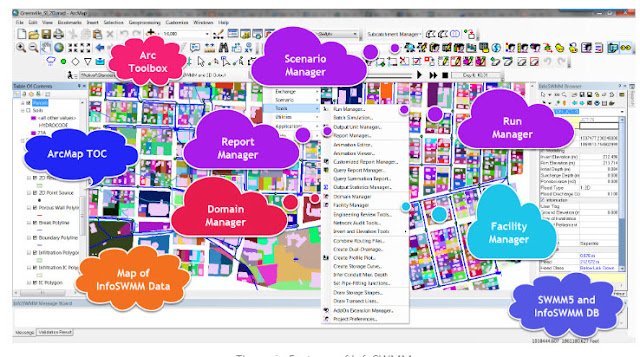
These are the top ten expanded reasons I have found over the last ten years for using InfoSWMM over the SWMM 5 GUI. I will start at the beginning that all of these fantastic features in InfoSWMM are due to our wonderful programmers in Monrovia (CA), Broomfield, Denver(CO) and Wallingford (UK).- Scenario, Database, and Facility Managers: InfoSWMM allows you to create and manage present and future scenarios. Its facility manager function facilitates the activation and deactivation of network sections, the creation of smaller networks, and selective network simulation for calibration or design purposes.
- Domain and Selection Sets: InfoSWMM's Domain and Selection Sets are handy tools for editing and creating graphic outputs.
- Extraction and Data Tools: With InfoSWMM, users have access to over 200 tools for Elevation Extraction, Pond Extraction, Data Inference, Data Connectivity, and more. These tools, based on proven technology and creativity, were developed during the past 22 years of InfoWater development at Innovyze.
- Arc Map Attribute Table Editing and Layer Properties: InfoSWMM integrates with Arc Map to provide attribute table editing, layer properties customization, and the use of Python scripts in ArcTool Box. Users can also use Arc Map editing tools to alter, edit, or expand their modeling network.
- Network Element and Output File Database Editing: InfoSWMM enables database editing of network elements and output files in the Attribute Browser, DB Tables, or the Output Report Manager Tables and Graphs.
- Output Graphs and Map Displays: InfoSWMM comes with various output graphs and map displays, alongside editable DB tables of the SWMM5 engine reports for Subcatchments, Links, Nodes, LID Units for all scenarios, and calibration graphs.
- Output Relates, Data Base Queries, and Output Statistical Tables: InfoSWMM provides Output Relates, Database Queries, and Output Statistical Tables for up to 500 Network Elements for Continuous Simulations.
- InfoSWMM Add-ons: InfoSWMM has various add-ons, including InfoSWMM 2D, InfoSWMM SFEM, InfoSWMM CapPlan, InfoSWMM connection to SWMMLive, and InfoSWMM connection to InfoMaster for CAP Planning.
- Genetic Algorithm Suite Addons: These add-ons are designed for Calibration parameter estimation for different elements such as surface hydrology, subsurface hydrology, infiltration, pumps, wet wells, links, and the RTK parameters in RDII hydrology.
- Suite Addons for Watershed Generation, Dry Weather Flow Estimation, and Other Functions: There are other Suite Addons that are designed for functions like Watershed Generation, Dry Weather Flow Estimation, Conduit Storage Synthesis, Pond Design Manager, Risk Assessment Manager, Google Earth Net View, InfoSWMM 2D, InfoSWMM Sustain for Green Infrastructure Optimization and Capacity Planning.
In conclusion, InfoSWMM offers many data exchange tools such as ODBC, GIS Gateway, Import, and Export Manager, along with excellent SWMM 5 import and InfoSewer direct import capabilities. It supports importing and exporting from and to various formats like XLS, CSV, Shapefiles, GeoDatabases, and more. It can also import and export models from other products like InfoSewer, InfoMaster Sewer, and InfoWorks_ICM using SWMM5 files, CSV, GeoDatabases, or Shapefiles. All these make InfoSWMM a superior choice over the SWMM 5 GUI.
Introduction: 📘 Ever since 1980, my journey with SWMM has been a thrilling ride 🎢. From co-authoring and co-developing SWMM3, SWMM4 in 1988, to being a part of the SWMM 5 development in the early 2000s, it's been a fulfilling experience. 🌟 Since 2008, my role as a Product Sector Leader at Innovyze has deepened my admiration for powerful tools like InfoSWMM, InfoWater, ICM, H2OMap SWMM, and InfoSewer. 🖥️ This post is a tribute to InfoSWMM's unparalleled capabilities and why it is superior to just using the SWMM 5 engine and GUI from the USEPA. 🚀
Historical Glimpse of InfoSWMM 🕰️: InfoSWMM, integrated with ArcGIS (Esri, Redlands, CA), is a game-changer. 💡 It's a beacon for engineers, offering seamless management of gigantic network models with features like 64-bit simulation, enhanced water quality modeling, and batch run scenario management. 🌍 The platform addresses every operational aspect of a sewer system, from design to analysis, in one integrated environment. Its computational engine, built on the foundation of the current SWMM 5 version, is endorsed by the USEPA and certified by FEMA. ✅
Top Ten Reasons for Preferring InfoSWMM over SWMM 5 🏆:
Scenario, Database, and Facility Managers 📂: InfoSWMM's robust framework allows the creation and management of various scenarios. It simplifies tasks like activating/deactivating network sections and even selective simulations.
Domain and Selection Sets 🎯: This feature makes editing and graphic output creation a breeze.
Extraction and Data Tools 🔧: Over 200 tools, including Elevation Extraction, Data Connectivity, and more, make InfoSWMM incredibly versatile.
Integration with Arc Map 🗺️: Attribute table editing, layer properties customization, and the ability to use Python scripts set InfoSWMM apart.
Network Editing Abilities 🛠️: From network elements to output files, InfoSWMM offers comprehensive database editing capabilities.
Output Visualization 📊: InfoSWMM boasts a variety of output graphs, map displays, and editable DB tables to make sense of complex data.
Advanced Analysis Tools 🔍: Output Relates, Database Queries, and Statistical Tables are just the tip of the iceberg.
InfoSWMM Add-ons 🧩: Whether it's InfoSWMM 2D, InfoSWMM SFEM, or the InfoSWMM connection to InfoMaster for CAP Planning, the range of add-ons is vast.
Genetic Algorithm Suite Addons 🧬: Calibration parameter estimation for various elements becomes effortless with these.
Miscellaneous Suite Addons 📦: From Watershed Generation to Green Infrastructure Optimization, these addons cover a broad spectrum.
Conclusion 🌠: InfoSWMM stands out with its plethora of data exchange tools, impeccable import/export capabilities, and compatibility with various formats and products. It's not just about modeling; it's about modeling right. And that's why InfoSWMM is a league above the SWMM 5 GUI. 🚀🌐


