Sunday, February 5, 2023

Urban flooding from WrathofGnon on Twitter - with added Emojis

Urban Flooding: Challenges and Solutions 🌧🌆

Urban flooding, characterized by the sudden inundation of urban landscapes, is often triggered by intense rainfall, stormwater overflow, or even coastal surges. Factors fueling this phenomenon span from inadequately designed stormwater systems and rapid urban sprawl to the proliferation of impermeable surfaces.

Impacts of Urban Flooding 🌊🏢:

  1. Property Damage: Floodwaters can invade homes and businesses, causing extensive structural damage.
  2. Transportation Disruption: Flooded roads and transport routes can halt movement, impacting daily life and commerce.
  3. Utilities Outage: Essential services like electricity may be compromised.
  4. Public Health Concerns: Stagnant floodwaters can become breeding grounds for diseases and introduce waterborne pathogens.
  5. Environmental Effects: The aftermath includes soil erosion and diminished water quality, with long-term flood risks increasing.

Factors Exacerbating Urban Flooding 🏙:

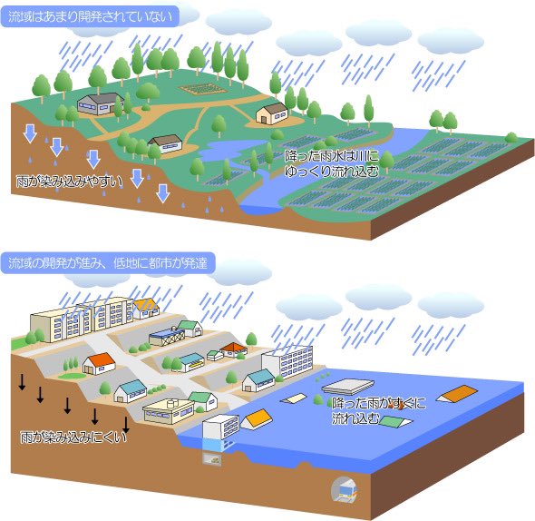
  • Hard Surfaces: Concrete and asphalt prevalent in urban areas impede the ground's natural absorption ability.
  • Built Environment: Urban constructions can inadvertently direct stormwater into confined channels, elevating the water's speed and volume, and thus the flood risk.

Preventive Measures and Mitigation 🌳🔧:

  1. Green Infrastructure: Embracing solutions like green roofs, permeable pavements, and rain gardens can help absorb and manage water.
  2. Stormwater Management Enhancement: Upgrading the existing stormwater systems to accommodate more significant volumes and implementing advanced drainage techniques can be pivotal.
  3. Land Use Planning: Advocating for sustainable land development and zoning practices can curb the adverse impacts of urbanization on flooding.

In essence, urban flooding is a formidable challenge, but with conscious efforts, its impacts can be considerably mitigated. Communities need to blend traditional infrastructure with innovative solutions to foster resilience against this growing urban menace. Source 🌍💡.


Saturday, February 4, 2023

ChatGPT Version of the SWMM5 Wikipedia Page History

 The Storm Water Management Model (SWMM) is a widely used software application developed by the U.S. Environmental Protection Agency (EPA) for simulating the hydrologic and hydraulic processes in urban drainage systems. The first version of SWMM was released in the early 1970s, and since then, it has undergone four major upgrades, with the latest being Version 5, released in the early 2000s.

The current version of SWMM, Version 5/5.2.1, is written in the programming language C and can be run on various Windows operating systems and Unix platforms. The code for SWMM 5 is open source and can be freely downloaded from the EPA website.

SWMM 5 provides a comprehensive graphical interface for editing watershed input data, performing hydrologic, hydraulic, real-time control, and water quality simulations, and viewing the results in various formats such as thematic drainage area maps, time-series graphs and tables, profile plots, scatter plots, and statistical frequency analyses.

The development of SWMM 5 was carried out by the Water Supply and Water Resources Division of the EPA's National Risk Management Research Laboratory in collaboration with the consulting firm CDM Inc. under a Cooperative Research and Development Agreement (CRADA). The software is widely used as the computational engine for many modeling packages and some of its components are also incorporated into other modeling packages.

SWMM 5 has been approved by the Federal Emergency Management Agency (FEMA) for use in the National Flood Insurance Program (NFIP) modeling and has been included in the FEMA Model Approval Page since May 2005. The updated history of SWMM 5 from its original version to the current version can be found on the EPA website.

Thursday, February 2, 2023

ChatGPT Version of the SWMM5 Wikipedia Page Introduction

 The EPA Storm Water Management Model (SWMM) is a computer software that simulates the rainfall-runoff-routing process in urban areas. It operates by dividing the study area into smaller subcatchment areas, where the hydrologic processes producing runoff are accounted for, including time-varying rainfall, evaporation, snow accumulation, depression storage, and more. The runoff is then routed through a network of pipes, channels, storage/treatment units, pumps, and regulators using hydraulic modeling techniques. The model can handle networks of any size, model different flow regimes, and use either kinematic wave or dynamic wave flow routing methods.

SWMM has been widely used in various applications, such as flood control, waste load allocation studies, and master planning of sewer collection systems. It is public domain software that can be freely copied and distributed, with the C engine code and Delphi graphical user interface code easily edited for custom features.

Applications:

  • Design and sizing of drainage system components for flood control
  • Sizing of detention facilities for flood control and water quality protection
  • Flood plain mapping of natural channel systems
  • Minimizing Combined Sewer Overflow (CSO) and Sanitary Sewer Overflow (SSO)
  • Evaluating the impact of inflow and infiltration on sanitary sewer overflows
  • Generating non-point source pollutant loadings for waste load allocation studies
  • Evaluating the effectiveness of Best Management Practices (BMPs) and Low Impact Development (LID) practices
  • Rainfall-runoff modeling of urban and rural watersheds
  • Hydraulic and water quality analysis of storm, sanitary, and combined sewer systems
  • Master planning of sewer collection systems and urban watersheds
  • System evaluations associated with EPA regulations, such as NPDES permits, CMOM, and TMDL
  • 1D and 2D predictions of flood levels and flooding volume

Hydrologic Processes Accounted for in SWMM:

  • Time-varying rainfall
  • Evaporation of standing surface water
  • Snow accumulation and melting
  • Rainfall interception from depression storage
  • Infiltration of rainfall into unsaturated soil layers
  • Percolation of infiltrated water into groundwater layers
  • Interflow between groundwater and the drainage system
  • Nonlinear reservoir routing of overland flow
  • Capture and retention of rainfall/runoff by LID practices

Hydraulic Modeling Capabilities:

  • Handle networks of unlimited size
  • Use a variety of standard closed and open conduit shapes and natural channels
  • Model special elements such as storage/treatment units, flow dividers, pumps, weirs, and orifices
  • Apply external flows and water quality inputs from various sources
  • Use either kinematic wave or full dynamic wave flow routing methods
  • Model various flow regimes, such as backwater, surcharging, reverse flow, and surface ponding
  • Apply user-defined dynamic control rules to simulate the operation of pumps, orifice openings, and weir crest levels.

Friday, January 27, 2023

XPSWMM to ICM SWMM or ICM Process Pathways


#ProcessDescription
1Technical details about how XPSWMM models a featureThis process involves understanding the specific algorithms, equations, and data inputs used by XPSWMM to model different features of an urban drainage system, such as hydrology, hydraulics, and water quality. This includes understanding how XPSWMM calculates runoff, infiltration, evaporation, and other hydrologic processes, as well as how it models the flow and routing of water through the drainage system.
2The process of exporting a XPSWMM model to XPXThis process involves using the export functionality in XPSWMM to save the model in a format that can be used in the XPX software. This includes selecting the components of the model to export, specifying the export location, and ensuring that the exported file is in a format that can be read by XPX.
3The process of exporting a XPSWMM model to SWMM5This process involves using the export functionality in XPSWMM to save the model in a format that can be used in the SWMM5 software. This includes selecting the components of the model to export, specifying the export location, and ensuring that the exported file is in a format that can be read by SWMM5.
4The process of importing the SWMM5 model to ICM SWMMThis process involves using the import functionality in ICM SWMM to load the model exported from SWMM5. This includes specifying the location of the exported file, mapping the components of the model to the appropriate inputs in ICM SWMM, and checking for any errors or inconsistencies in the imported model.
5The process of importing the SWMM5 model to ICMThis process involves using the import functionality in ICM to load the model exported from SWMM5. This includes specifying the location of the exported file, mapping the components of the model to the appropriate inputs in ICM, and checking for any errors or inconsistencies in the imported model.
6Validating the ICM SWMM ImportThis process involves checking the imported model in ICM SWMM for errors or inconsistencies. This includes comparing the imported data to the original XPSWMM model, checking for missing or incorrect data, and making any necessary adjustments to the imported model before running the simulation.
7Converting the ICM SWMM network to ICMThis process involves converting the imported model in ICM SWMM to the format used by the ICM software. This includes mapping the components of the model to the appropriate inputs in ICM, and making any necessary adjustments to the imported model before running the simulation.
8Getting either ICM or ICM SWMM to runThis process involves configuring the software and the model, and then running the simulation. This includes setting the simulation parameters, specifying the time step and duration of the simulation, and specifying the output options.
9Compare answers to XPSWMMThis process involves comparing the results of the XPSWMM simulation to the results of the simulation run in ICM or ICM SWMM. This includes comparing the hydrographs, water surface elevations, and other output variables, and identifying any discrepancies or issues with the results.
10Technical details on how SWMM5 or ICM work compared to XPSWMMThis process involves identifying and implementing solutions to issues or problems that may arise during the use of the software or the simulation.

Sunday, January 22, 2023

SWMM 5.2.2 LID code for readSurfaceData

This code reads data for a specific LID process from a line of an input file, and assigns the data to variables in an array called "LidProcs". The data includes values for storage height, vegetation volume fraction, roughness, surface slope, and side slope. The code first checks if there are enough tokens in the input file, and then uses a loop to check if each token is a valid number and is greater than or equal to 0. If any of these conditions are not met, an error code is returned. The code then assigns the data to the appropriate variables in the LidProcs array, after converting the units and making sure that some values are set to 0 if other values meet certain conditions. The code returns 0 if there is no error.

int readSurfaceData(int j, char* toks[], int ntoks)
//
//  Purpose: reads surface layer data for a LID process from line of input
//           data file
//  Input:   j = LID process index 
//           toks = array of string tokens
//           ntoks = number of tokens
//  Output:  returns error code
//
//  Format of data is:
//  LID_ID  SURFACE  StorageHt  VegVolFrac  Roughness  SurfSlope  SideSlope
//
{
    int    i;
    double x[5];

    if ( ntoks < 7 ) return error_setInpError(ERR_ITEMS, "");
    for (i = 2; i < 7; i++)
    {
        if ( ! getDouble(toks[i], &x[i-2]) || x[i-2] < 0.0 )
            return error_setInpError(ERR_NUMBER, toks[i]);
    }
    if ( x[1] >= 1.0 ) return error_setInpError(ERR_NUMBER, toks[3]);           
    if ( x[0] == 0.0 ) x[1] = 0.0;

    LidProcs[j].surface.thickness     = x[0] / UCF(RAINDEPTH);
    LidProcs[j].surface.voidFrac      = 1.0 - x[1];
    LidProcs[j].surface.roughness     = x[2];
    LidProcs[j].surface.surfSlope     = x[3] / 100.0;
    LidProcs[j].surface.sideSlope     = x[4];
    return 0;
}

AI Rivers of Wisdom about ICM SWMM

Here's the text "Rivers of Wisdom" formatted with one sentence per line: [Verse 1] 🌊 Beneath the ancient oak, where shadows p...