Showing posts with label InfoSWMM. Show all posts

Saturday, September 3, 2016

How to Rectify Offset Issues in InfoSWMM and H2OMap SWMM

How to Rectify Offset Issues in InfoSWMM and H2OMap SWMM
1. Use Tool preferences to use elevation Rim Elevations (instead of depths) and elevation link offsets (instead of depths)
2. Once these flags are set you need to divide all of the link offsets by 2 to get the original values
3. The node and links should be correct
4. Check a portion of your model using the Input HGL tool to see if the offsets make sense
5. You should always check to see if you have the right elevation preferences
a. Offsets of depth and Node Max Depth or
b. Offsets of absolute elevation and Rim Absolute Elevations instead of Depths

Tuesday, June 21, 2016

Innovyze Releases InfoSWMM Generation V14.5, Spearheading New Era in GIS-Centric Smart Wastewater and Stormwater Modeling

Innovyze Releases InfoSWMM Generation V14.5, Spearheading New Era in GIS-Centric Smart Wastewater and Stormwater Modeling

New Version, Available for Download Immediately, Delivers Unrivaled High-Performance Simulation Capabilities for Unprecedentedly Large Urban Drainage Systems

Broomfield, Colorado, USA, June 21, 2016

In its ongoing quest to equip the wastewater industry with the world’s most comprehensive and innovative smart network modeling and management solutions, Innovyze, a leading global innovator of business analytics software and technologies for smart wet infrastructure, today announced the worldwide availability of the V14.5 Generation of its industry-leading InfoSWMM for ArcGIS (Esri, Redlands, CA). InfoSWMM V14.5 provides unique new capabilities and enhancements that comprise the most advanced approach to guiding and optimizing the planning, design, operation and management of larger and more complex urban drainage systems than ever before, including networks with over one million elements. It delivers many applications for drainage systems in non-urban areas as well.

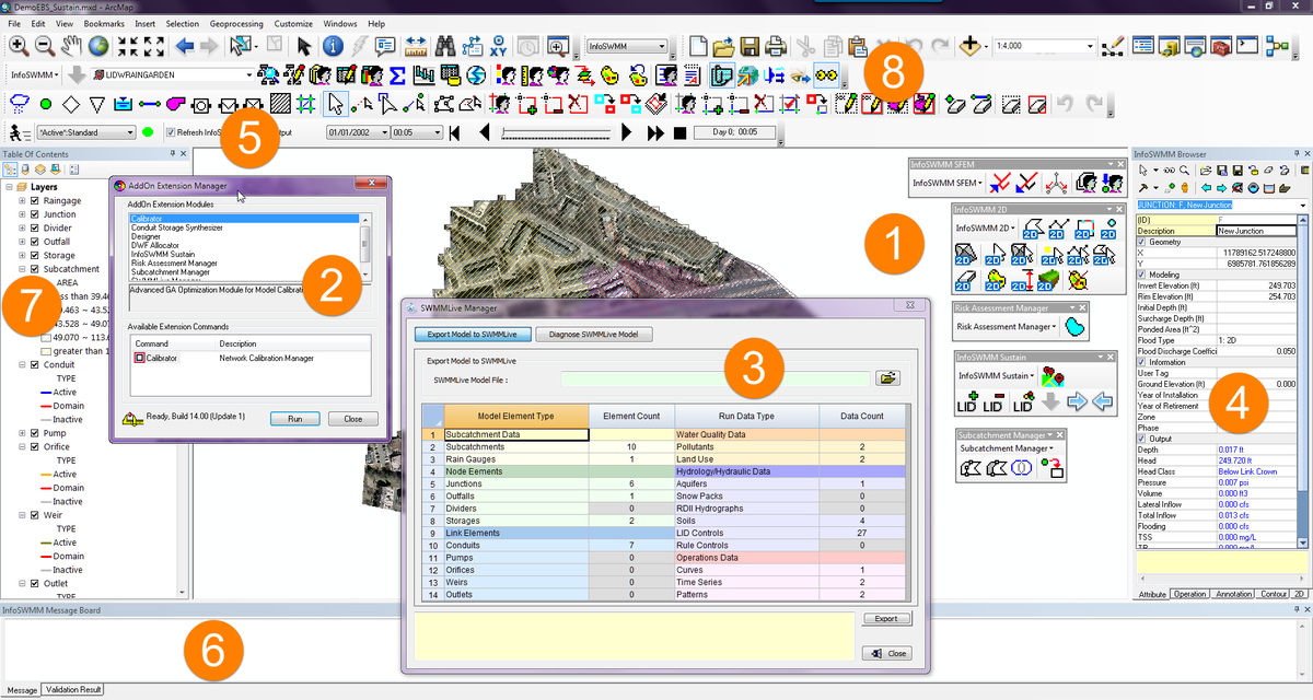
A complete ArcGIS-centric urban drainage modeling solution, the full-featured InfoSWMM analysis and design program delivers the highest rate of return in the industry. All operations of a typical collection system — from analysis and design to management functions such as water quality assessment, hydrogen sulfide and pollution prediction, sediment transport and deposition, urban flooding, real-time control, and record keeping — are addressed in a single, fully integrated geoengineering environment. It can also accurately represent and analyze any combination of LID controls and green infrastructure to determine their effectiveness in managing stormwater and combined sewer overflows. The program’s powerful hydraulic and water quality computational engine is based on an improved and faster version of the latest USEPA SWMM 5, certified by FEMA. These features and more deliver an enhanced modeling experience and greater realism of displayed results — advantages that translate to increased productivity, reduced costs, higher accuracy, better efficiency, and improved designs.

InfoSWMM also serves as a robust base platform for advanced modeling, operational, short-term and long range planning, capital planning, urban stormwater treatment and analysis, and analytics-driven asset management extensions. Some of these critical applications include InfoSWMM Sustain (optimal selection and placement of green infrastructure), InfoSWMM 2D (two-dimensional surface flood modeling), SWMMLive (real-time urban drainage modeling), CapPlan (risk-based capital planning and asset performance modeling), InfoSWMM SFEM (dynamic sewer flow estimation model), InfoMaster (GIS-centric analytics-driven asset management), and RDII Analyst (rainfall-dependent inflow and infiltration planning and analysis).

The release of 
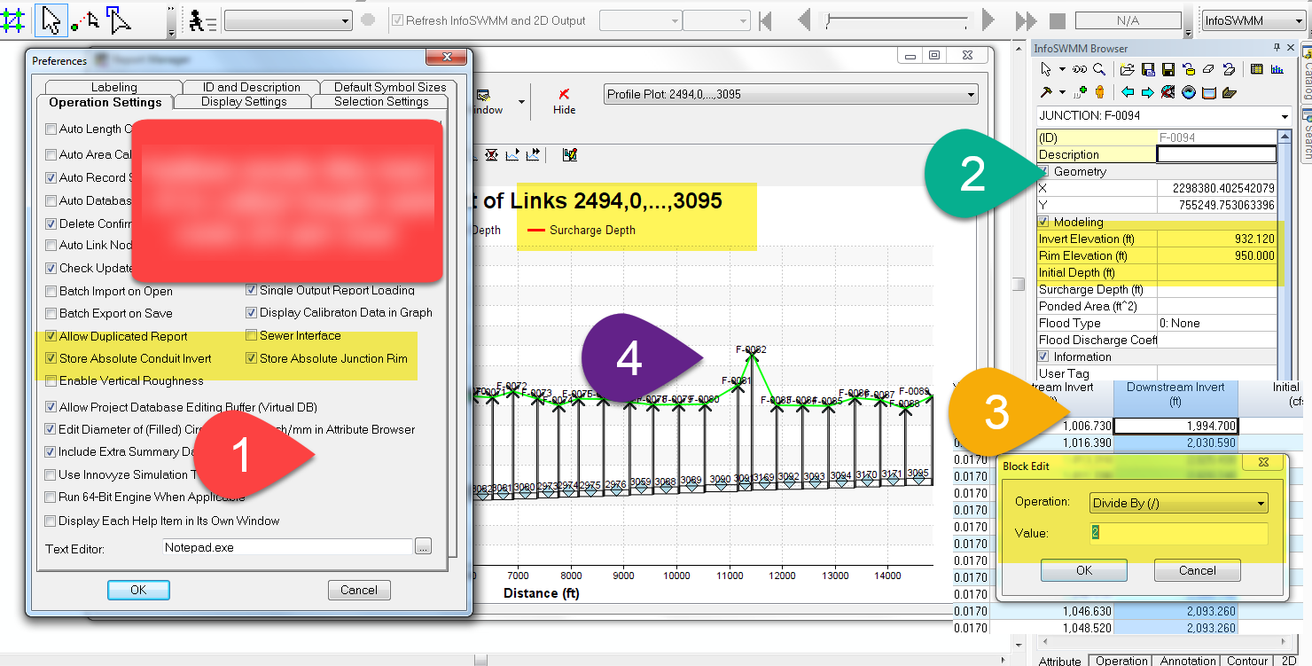
InfoSWMM V14.5 extends the capabilities of previous generations with new features, improvements, and groundbreaking innovations in geoengineering productivity and efficiency as well as an enhanced user experience. These advances, requested by our users, greatly simplify, accelerate, and integrate urban drainage network engineering, helping wastewater and stormwater engineers develop better designs and operational improvements faster. The new release includes the ability to skip dry weather or steady-state periods, an important plus for long-term simulations. The user may specify storms of interest while retaining the capability to simulate continuous hydrology, such as seasonal groundwater variations. This functionality allows results files to remain manageable while evaluating a sewer system over a long term period, period of record or typical year analysis. Other enhancements include direct connection to SCADAWatch for model calibration and verification with real-time data, automated export to HEC-RAS, optimized export of very large time series, complete support of 64-bit simulation runs, expanded storage curve calculator to automatically define depths and boundaries of all BMPs, and the ability to expeditiously generate RTK parameters.

“Our priorities have always been to advance the frontiers of smart network modeling technology and support our customers’ successes by helping them be more productive, innovative and competitive —imperative advantages in today’s economy,” said Paul F. Boulos, Ph.D., BCEEM, Hon.D.WRE, Dist.D.NE, Dist.M.ASCE, NAE, President, COO and Chief Innovation Officer of Innovyze. “This major InfoSWMM release delivers on our promise to equip our customers with the ultimate ArcGIS-centric decision support tool for sewer collection and urban drainage systems. Like its predecessors, InfoSWMM V14.5 sets a new standard for quality and high-performance network modeling and management with unrivaled power and speed, cutting-edge capabilities, rich functionality and ease of use. From top to bottom, it is designed for record modeling performance of larger systems than ever, enabling users to increase productivity and quality while achieving engineering, sustainability and business goals. We will continue to work hard to provide our customers with the best GIS-centric modeling solutions to help them design, build, manage and operate safe, sustainable and resilient hydraulic infrastructure systems and drive engineering success.”

Added Robert E. Dickinson, Product Sector Leader for Innovyze, “Improving modeling accuracy and effectively interfacing with GIS applications requires the use of large, detailed operational models of the urban drainage system. With this decisive performance, InfoSWMM has raised the standard of all-element urban drainage network modeling to new levels of reliability, fidelity and performance, giving our customers significant boosts in productivity and efficiencies.”

Pricing and Availability 
Upgrade to InfoSWMM V14.5 (and H2OMAP SWMM V14.5) is now available worldwide by subscription. Subscription members can immediately download the new version free of charge directly from www.innovyze.com. The Innovyze Subscription Program is a friendly customer support and software maintenance program that ensures the longevity and usefulness of Innovyze products. It gives subscribers instant access to new functionality as it is developed, along with automatic software updates and upgrades. For the latest information on the Innovyze Subscription Program, visitwww.innovyze.com or contact your local Innovyze Channel Partner.
About InnovyzeInnovyze is a leading global provider of wet infrastructure business analytics software solutions designed to meet the technological needs of water/wastewater utilities, government agencies, and engineering organizations worldwide. Its clients include the majority of the largest UK, Australasian, East Asian and North American cities, foremost utilities on all five continents, and ENR top-rated design firms. With unparalleled expertise and offices in North America, Europe and Asia Pacific, the Innovyze connected portfolio of best-in-class product lines empowers thousands of engineers to competitively plan, manage, design, protect, operate and sustain highly efficient and reliable infrastructure systems, and provides an enduring platform for customer success. For more information, call Innovyze at +1 626-568-6868, or visit www.innovyze.com.
Innovyze Contact:Rajan RayDirector of Marketing and Client Service Manager
Rajan.Ray@innovyze.com
+1 626-568-6868
- See more at: http://www.innovyze.com/news/1686/Innovyze_Releases_InfoSWMM_Generation_V14.5,_Spearheading_New_Era_in_GIS-Centric_Smart_Wastewater_and_Stormwater_Modeling#sthash.nYqBiqjO.dpuf

Monday, May 16, 2016

Annotated PID Controller in SWMM5 and InfoSWMM

How does a PID controller work in  InfoSWMM  and SWMMM 5 - this also applies to H2OMap SWMM??
double getPIDSetting(struct TAction* a, double dt)   //  at each time  step find  the PID control  changes for the  current  time step dt
// Input: a = an action object
// dt = current time step (days)
// Output: returns a new link setting
// Purpose: computes a new setting for a link subject to a PID controller.
pid1
// Note: a->kp = gain coefficient,
// a->ki = integral time (minutes)
// a->k2 = derivative time (minutes)
// a->e1 = error from previous time step
// a->e2 = error from two time steps ago
{
double e0, setting;
double p, i, d, update;
double tolerance = 0.0001;
// --- convert time step from days to minutes
dt *= 1440.0;
// --- determine relative error in achieving controller set point
// Or how close are we to the set point?
PID2
e0 = SetPoint - ControlValue;
if ( fabs(e0) > TINY )
{
if ( SetPoint != 0.0 ) e0 = e0/SetPoint;
// now alter the  value of e0
PID3
else e0 = e0/ControlValue;
}
// --- reset previous errors to 0 if controller gets stuck
if (fabs(e0 - a->e1) < tolerance)
{
a->e2 = 0.0;
a->e1 = 0.0;
}
// --- use the recursive form of the PID controller equation to
// determine the new setting for the controlled link
Here is a view of the p, i and d PID internal  parameters https://www.wikiwand.com/en/PID_controller
A block diagram of a PID controller in a feedback loop
p = (e0 - a->e1);
pid5
ki, id,  kp are  user  inputs  in InfoSWMM and SWMM5 or from the  EPA SWMM  5 Help  File2016-05-16_0548.png
if ( a->ki == 0.0 ) i = 0.0;
else i = e0 * dt / a->ki;
pd8.png
d = a->kd * (e0 - 2.0*a->e1 + a->e2) / dt;
pid9
update = a->kp * (p + i + d);
if ( fabs(update) < tolerance ) update = 0.0;
setting = Link[a->link].targetSetting + update;
pid7
// --- update previous errors
a->e2 = a->e1;
a->e1 = e0;
// --- check that new setting lies within feasible limits
// If  the link  is not a pump then the  setting must be between 0 and 1
if ( setting < 0.0 ) setting = 0.0;
if (Link[a->link].type != PUMP && setting > 1.0 ) setting = 1.0;
return setting;}

Tuesday, April 12, 2016

InfoSWMM Sustain Generation V2.0 Delivers Significant Advancements for Comprehensive Urban Stormwater Treatment and Analysis

InfoSWMM Sustain Generation V2.0 Delivers Significant Advancements for Comprehensive Urban Stormwater Treatment and Analysis

Latest Release Confirms Product’s Role as Industry Leading GIS-Centric Solution for Determining Optimal Green Infrastructure Strategies

Broomfield, Colorado, USA, April 12, 2016

Innovyze, a leading global innovator of business analytics software and technologies for smart wet infrastructure, today announced  worldwide availability of the V2.0 Generation of its industry-leading InfoSWMM Sustain for comprehensive urban stormwater treatment and analysis. The new version lets users quickly and reliably determine optimal green infrastructure strategies for reducing volume and peak flows to combined sewer systems as well as evaluating the benefits of distributed green infrastructure implementation on water quantity and quality in urban streams.

InfoSWMM Sustain is a comprehensive geocentric decision support system created to assist stormwater management professionals in developing and implementing plans for flow and pollution control measures to protect source waters and meet water quality goals. The software allows users to locate, develop, evaluate, and select optimal best management practice (BMP), low impact development (LID) and Sustainable Urban Drainage Systems (SUDS) combinations at various watershed scales based on cost and effectiveness. It can accurately model any combination of LID controls, such as porous permeable pavement, rain gardens, green roofs, street planters, rain barrels, infiltration trenches and vegetative swales to determine their effectiveness in managing stormwater and combined sewer overflows. Furthermore, InfoSWMM Sustain will automatically assess the geographic properties in the study area including soil properties, land use, slope, building footprint, groundwater, land ownership, imperviousness and other pertinent factors to determine all possible locations of feasible green infrastructure alternatives. These expanded capabilities can greatly assist users in developing cost-effective and reliable implementation plans for flow and pollution control aimed at protecting source waters and meeting water quality goals. They do so by helping users answer key questions: How effective are BMPs in reducing runoff and pollutant loadings? What are the most cost-effective solutions for meeting water quality and quantity objectives? Where, what type, and how extensive should BMPs be?

By seamlessly integrating ArcGIS 10.x (Esri, Redlands, CA) with SWMM 5.1, InfoSWMM Sustain greatly expands and improves on the USEPA SUSTAIN software to provide critically needed support to watershed practitioners at all levels in developing stormwater management evaluations and cost optimizations to meet their program needs. The software can automatically import any SWMM 5.1, InfoSWMM or InfoWorks ICM (exported to SWMM 5.1) model, then evaluate numerous potential combinations of BMPs and LIDs to determine the optimal combination to meet specified objectives such as runoff volume or pollutant loading reductions. Both kinematic wave and full dynamic wave flow routing models are fully supported. Among its many vital applications, InfoSWMM Sustain can be effectively used in developing TMDL implementation plans, identifying management practices to achieve pollutant reductions under a separate municipal storm sewer system (MS4) stormwater permit, determining optimal green infrastructure strategies for reducing volume and peak flows to combined sewer systems, evaluating the benefits of distributed green infrastructure implementation on water quantity and quality in urban streams, and developing a phased BMP installation plan using cost effectiveness curves.

Among its many major enhancements, Version 2.0 lets users optimize the entire system (using advanced Genetic Algorithms), not only individual subcatchments. Users can also choose a system-wide budget constraint and reduction target for runoff and/or pollution, view LID design and performance directly from the Cost Effectiveness Curve, compare hydrographs for runoff and pollutant of the various solutions on the Cost Effectiveness Curve, implement any desired LID design solution in InfoSWMM, and display the optimal system-wide runoff/pollutant reduction. The new release also introduces an improved, more intuitive user interface that visually highlights and simplifies the workflow process. Users can now quickly evaluate complex decisions about green infrastructure selection and placement performance, costs for meeting flow or water quality targets, or both. The software gives them the power they need to maximize water quality benefits, minimize stormwater management costs and combined sewer overflows, and protect the environment and public health.

“With InfoSWMM Sustain, we are extending our success in the smart network modeling marketplace to address the specific needs of stormwater management professionals and their engineering consultants,” said Paul F. Boulos, Ph.D., BCEEM, Hon.D.WRE, Dist.D.NE, Dist.M.ASCE, NAE, President, COO and Chief Technical Officer of Innovyze. “The new release performs very sophisticated hydrologic and water quality modeling in watersheds and urban streams, and enables users to determine optimal management solutions at multiple-scale watersheds to achieve desired water quality objectives based on cost effectiveness. It also gives users the power tool they need to maximize water quality benefits, minimize stormwater management costs and combined sewer overflows, and protect the environment and public health. This is a must-have for predicting the environmental outcomes of different design and management approaches as well as developing optimal plans for flow and pollution control to protect source waters and meet water quality goals.”

Pricing and Availability 
Upgrade to InfoSWMM Sustain V2.0 is now available worldwide by subscription. Subscription members can immediately download the new version free of charge directly from www.innovyze.com. The Innovyze Subscription Program is a friendly customer support and software maintenance program that ensures the longevity and usefulness of Innovyze products. It gives subscribers instant access to new functionality as it is developed, along with automatic software updates and upgrades. For the latest information on the Innovyze Subscription Program, visit www.innovyze.com or contact your local Innovyze Channel Partner.
About InnovyzeInnovyze is a leading global provider of wet infrastructure business analytics software solutions designed to meet the technological needs of water/wastewater utilities, government agencies, and engineering organizations worldwide. Its clients include the majority of the largest UK, Australasian, East Asian and North American cities, foremost utilities on all five continents, and ENR top-rated design firms. With unparalleled expertise and offices in North America, Europe and Asia Pacific, the Innovyze connected portfolio of best-in-class product lines empowers thousands of engineers to competitively plan, manage, design, protect, operate and sustain highly efficient and reliable infrastructure systems, and provides an enduring platform for customer success. For more information, call Innovyze at +1 626-568-6868, or visit www.innovyze.com.
Innovyze Contact:Rajan RayDirector of Marketing and Client Service Manager
Rajan.Ray@innovyze.com
+1 626-568-6868
- See more at: http://www.innovyze.com/news/1672/#sthash.BhyC5GxG.dpuf

Tuesday, March 15, 2016

Innovyze Further Expands RDII Analyst Functionality, Setting New Standard for Sanitary and Combined Sewer System Model Calibration

Innovyze Further Expands RDII Analyst Functionality, Setting New Standard for Sanitary and Combined Sewer System Model Calibration

New Features Allow Unprecedented Analysis and Comparison of Rainfall-Derived Inflow and Infiltration Data, Parameters for Complex Sewers

Broomfield, Colorado, USA, March 15, 2016

Innovyze, a leading global innovator of business analytics software and technologies for smart wet infrastructure, today announced the newest release of its RDII Analyst (Rainfall-Derived Inflow and Infiltration) for InfoSWMM and H2OMAP SWMM. The new version delivers expanded functionality, incorporating many advanced Genetic Algorithm (GA) optimization features. It increases its unmatched productivity by making it easy for users to further adjust the dry weather flow (DWF) and RTK parameters (with initial and maximum monthly storages for continuous simulation) to achieve a better fit and ultimately a better model based on their experiences. The release confirms Innovyze’s commitment to giving the world the most complete toolset for modeling current sanitary and combined sewer collection systems.

Excessive wet weather flow from rainfall-derived manhole and pipe defect inflow and infiltration is a major source of sanitary and combined sewer overflows. Controlling these overflows is vital in reducing risks to public health and protecting the environment from water pollution. Computer modeling plays an important role in determining sound and economical remedial solutions that reduce RDII; improve system integrity, reliability and performance; and avoid overflows.

The processes for converting rainfall to RDII flow in sanitary sewer systems are very complicated. In addition to rainfall and antecedent moisture conditions, factors controlling RDII responses include depth to groundwater, depth to bedrock, land slope, number and size of sewer system defects, type of storm drainage system, soil characteristics, and type of sewer backfill. Given this degree of complexity, flow-monitoring data must be combined with mathematical modeling and analytics to provide accurate results. The wastewater flow monitoring data obtained by sewer collection systems consists of dry-weather flow components, ground water flow and twelve (12) RDII flow components. A crucial step in successfully modeling sewer collection systems is the ability to decompose flow-monitoring data into RDII flow, ground water flow and dry weather flow and its flow pattern.

Significantly superior to the EPA Sanitary Sewer Overflow Analysis and Planning (SSOAP) program and powered by advanced GA optimization and comprehensive data analytics and scenario management, RDII Analyst provides the ability to quickly and reliably perform these types of advanced flow decomposition data monitoring. It has been updated with tabular comparisons between the observed and calibrated RDII data for each event, including R value, peak flow, hydrograph volume and depth. This allows the user to better evaluate simulated and monitored data and judge how well it correlates on a per event basis. The user can also directly edit estimated DWF mean values to apply site specific knowledge to the RDII Analyst DWF extraction algorithm. These altered DWF values can then be used to estimate the wet weather flow component of the monitored flow, using a combination of the DWF extraction algorithm and site-specific knowledge. The new version also allows direct edits to the twelve RTK and storage parameters plus manual curve fitting to apply site specific knowledge to the genetic algorithm parameter estimation. Manual curve fitting is valuable in timing differences between monitored and calibrated wet weather flow components and employing previous experience in estimating RTK parameters.

“Innovyze continues to listen to our customers, invest very heavily in R&D, and deliver the advanced tools they need to effectively support their wastewater and urban drainage modeling and management challenges,” said Paul F. Boulos, Ph.D., BCEEM, Hon.D.WRE, Dist.D.NE, Dist.M.ASCE, NAE, President, COO and Chief Technical Officer of Innovyze. “We are very excited that our vast worldwide customer base will now be able to use the powerful new features in RDII Analyst to enhance their modeling experiences, wrap better projects faster, and strengthen our communities’ sewer systems.”

Pricing and Availability
Upgrade to RDII Analyst is now available worldwide by subscription to the Executive program. Subscription members can immediately download the new version free of charge directly from www.innovyze.com. The Innovyze Subscription Program is a friendly customer support and software maintenance program that ensures the longevity and usefulness of Innovyze products. It gives subscribers instant access to new functionality as it is developed, along with automatic software updates and upgrades. For the latest information on the Innovyze Subscription Program, visit www.innovyze.com or contact your local Innovyze Channel Partner.
About InnovyzeInnovyze is a leading global provider of wet infrastructure business analytics software solutions designed to meet the technological needs of water/wastewater utilities, government agencies, and engineering organizations worldwide. Its clients include the majority of the largest UK, Australasian, East Asian and North American cities, foremost utilities on all five continents, and ENR top-rated design firms. With unparalleled expertise and offices in North America, Europe and Asia Pacific, the Innovyze connected portfolio of best-in-class product lines empowers thousands of engineers to competitively plan, manage, design, protect, operate and sustain highly efficient and reliable infrastructure systems, and provides an enduring platform for customer success. For more information, call Innovyze at +1 626-568-6868, or visit www.innovyze.com.
Innovyze Contact:Rajan RayDirector of Marketing and Client Service Manager
Rajan.Ray@innovyze.com
+1 626-568-6868
- See more at: http://www.innovyze.com/news/1667/Innovyze_Further_Expands_RDII_Analyst_Functionality,_Setting_New_Standard_for_Sanitary_and_Combined_Sewer_System_Model_Calibration#sthash.1h6ehlNs.dpuf

Tuesday, February 23, 2016

Innovyze Further Expands RDII Analyst Functionality, Setting New Standard for Sanitary and Combined Sewer System Model Calibration

Innovyze Further Expands RDII Analyst Functionality, Setting New Standard for Sanitary and Combined Sewer System Model Calibration

New Features Allow Unprecedented Analysis and Comparison of Rainfall-Derived Inflow and Infiltration Data, Parameters for Complex Sewers

Broomfield, Colorado, USA, February 23, 2016

Innovyze, a leading global innovator of business analytics software and technologies for smart wet infrastructure, today announced the newest release of its RDII Analyst (Rainfall-Derived Inflow and Infiltration) for InfoSWMM and H2OMAP SWMM. The new version delivers expanded functionality, incorporating many advanced Genetic Algorithm (GA) optimization features. It increases its unmatched productivity by openly inviting the users to further adjust the dry weather flow (DWF) and RTK parameters (with initial and maximum monthly storages for continuous simulation) to achieve a better fit and ultimately a better model based on their experiences. The release confirms Innovyze’s commitment to giving the world the most complete toolset for modeling current sanitary and combined sewer collection systems.

Excessive wet weather flow from rainfall-derived manhole and pipe defect inflow and infiltration is a major source of sanitary and combined sewer overflows. Controlling these overflows is vital in reducing risks to public health and protecting the environment from water pollution. Computer modeling plays an important role in determining sound and economical remedial solutions that reduce RDII; improve system integrity, reliability and performance; and avoid overflows.

The processes for converting rainfall to RDII flow in sanitary sewer systems are very complicated. In addition to rainfall and antecedent moisture conditions, factors controlling RDII responses include depth to groundwater, depth to bedrock, land slope, number and size of sewer system defects, type of storm drainage system, soil characteristics, and type of sewer backfill. Given this degree of complexity, flow-monitoring data must be combined with mathematical modeling and analytics to provide accurate results. The wastewater flow monitoring data obtained by sewer collection systems consists of dry-weather flow components, ground water flow and twelve (12) RDII flow components. A crucial step in successfully modeling sewer collection systems is the ability to decompose flow-monitoring data into RDII flow, ground water flow and dry weather flow and its flow pattern.

Significantly superior to the EPA Sanitary Sewer Overflow Analysis and Planning (SSOAP) program and powered by advanced GA optimization and comprehensive data analytics and scenario management, RDII Analyst provides the ability to quickly and reliably perform these types of advanced flow decomposition data monitoring. It has been updated with tabular comparisons between the observed and calibrated RDII data for each event, including R value, peak flow, hydrograph volume and depth. This allows the user to better evaluate simulated and monitored data and judge how well it correlates on a per event basis. The user can also directly edit estimated DWF mean values to apply site specific knowledge to the RDII Analyst DWF extraction algorithm. These altered DWF values can then be used to estimate the wet weather flow component of the monitored flow, using a combination of the DWF extraction algorithm and site-specific knowledge. The new version also allows direct edits to the twelve RTK and storage parameters plus manual curve fitting to apply site specific knowledge to the genetic algorithm parameter estimation. Manual curve fitting is valuable in timing differences between monitored and calibrated wet weather flow components and employing previous experience in estimating RTK parameters.

“Innovyze continues to listen to our customers, invest very heavily in R&D, and deliver the advanced tools they need to effectively support their wastewater and urban drainage modeling and management challenges,” said Paul F. Boulos, Ph.D., BCEEM, Hon.D.WRE, Dist.D.NE, Dist.M.ASCE, NAE, President, COO and Chief Technical Officer of Innovyze. “We are very excited that our vast worldwide customer base will now be able to use the powerful new features in RDII Analyst to enhance their modeling experiences, wrap better projects faster, and strengthen our communities’ sewer systems.”

Pricing and Availability
Upgrade to RDII Analyst is now available worldwide by subscription to the Executive program. Subscription members can immediately download the new version free of charge directly from www.innovyze.com. The Innovyze Subscription Program is a friendly customer support and software maintenance program that ensures the longevity and usefulness of Innovyze products. It gives subscribers instant access to new functionality as it is developed, along with automatic software updates and upgrades. For the latest information on the Innovyze Subscription Program, visit www.innovyze.com or contact your local Innovyze Channel Partner.
About InnovyzeInnovyze is a leading global provider of wet infrastructure business analytics software solutions designed to meet the technological needs of water/wastewater utilities, government agencies, and engineering organizations worldwide. Its clients include the majority of the largest UK, Australasian, East Asian and North American cities, foremost utilities on all five continents, and ENR top-rated design firms. With unparalleled expertise and offices in North America, Europe and Asia Pacific, the Innovyze connected portfolio of best-in-class product lines empowers thousands of engineers to competitively plan, manage, design, protect, operate and sustain highly efficient and reliable infrastructure systems, and provides an enduring platform for customer success. For more information, call Innovyze at +1 626-568-6868, or visit www.innovyze.com.
Innovyze Contact:Rajan RayDirector of Marketing and Client Service Manager
Rajan.Ray@innovyze.com
+1 626-568-6868
- See more at: http://www.innovyze.com/news/1664/#sthash.VMYZZnmf.dpuf

Thursday, December 17, 2015

There was a change in EPA SWMM 5.1 to better represent Weekend vs Weekday Hourly flow patterns

There was a change in EPA SWMM 5.1 to better represent Weekend vs Weekday Hourly flow patterns

Fields for the DWF Tables in H2OMap SWMM and InfoSWMM are:

1. Scenario Name
2. Junction ID for the node that receives the DWF
3. The item – either FLOW, MASS or Concentration (Use Blockedit to just set this at Flow for all Rows) and you should fix your problem.
4. Value – the flow in the units defined in the Run Manager
5. Pattern1 – Can be Weekend, Hourly (Weekday only), Monthly or Daily patterns.  They can be in any order but Hourly only applies Monday to Friday.
6. Pattern2 – Can be Weekend, Hourly (Weekday only), Monthly or Daily patterns. They can be in any order but Hourly only applies Monday to Friday.
7. Pattern3 – Can be Weekend, Hourly (Weekday only), Monthly or Daily patterns. They can be in any order but Hourly only applies Monday to Friday.
8. Pattern4 – Can be Weekend, Hourly (Weekday only), Monthly or Daily patterns. They can be in any order but Weekend only applies to Saturday and Sunday.
9. Alloc Code which is a tag from the DWF Allocator

It used to be that the two hourly patterns were applies as

… the week end flows are generated in the model by multiplying Node DWF x Hourly x Weekend x Daily x Monthly. 

But now

… the week end flows (Saturday and Sunday) are generated in the model by multiplying Node DWF x Weekend x Daily x Monthly. 

… the daily flows (Monday to Friday) flows are generated in the model by multiplying Node DWF x Hourly x Daily x Monthly.  

Wednesday, December 16, 2015

How to Tell how Long Normal Flow is used in a Link in #InfoSWMM, H2OMap SWMM w/ #SWMM5

How to Tell how Long Normal Flow is used in a Link in #InfoSWMM, H2OMap SWMM  w/ #SWMM5

Find the Fraction of Normal Flow Limited in the Flow Classification  Table and copy it to the Link Information Table - the value of FLM can then be Displayed in a Map using  the Map Display command.  In this small example, three links primarily used normal flow and one uses it for a short time. Normal flow only uses the Manning's equation and the link upstream depth, hydraulic radius and cross sectional area to compute the flow.


How to Tell how Long Normal Flow is used in a Link in #InfoSWMM, H2OMap SWMM  w/ #SWMM5
St. Venant equation solution – this is the link attribute data used when the St. Venant Equation is used in #SWMM 5. Simulated Parameters from the upstream, midpoint and downstream sections of the link are used.
Normal Flow Equation – this is the link attribute data used when the Normal Flow Equation is used in #SWMM 5. Only simulated parameters from the upstream end of the link are used if the normal flow equation is used for the time step.

Tuesday, October 13, 2015

Steps in #INFOSWMM for Using and Saving Hot Start Files for Quasi Steady State Runs

Steps in #INFOSWMM for Using and Saving Hot Start Files for Quasi Steady State Runs

1. Two Scenario's to Save and then Use a Hot Start File 

2. Save and Use the Hot Start Files 

3. Graph the Depth and Flow of the Scenario that uses the Hot Start File, the depths and flows should be connstant 

4. You can see the time step values in the Attribute Browser 

5. Map Display Depth on the Map to see the flows and depths are steady

Steps in #INFOSWMM for Using and Saving Hot Start Files for Quasi Steady State Runs 

Sunday, October 4, 2015

#INFOSWMM Genetic Algorithm Suite Programs Calibrator and Designer


Components of #INFOSWMM from @Innovyze


Tweets - Components of #INFOSWMM from @Innovyze

  1. 8/ Components of from Managers of your Map and DB Data Bullet 8
  2. 7/ Components of from Map Table of Contents Map to DB Link for GIS or Bullet 7
  3. 6/ Components of from Message Box for User Information from Arc GIS or Bullet 6
  4. 5/ Components of from Tools for Adding New Map Features or Bullet 5
  5. 4/ Components of from Attribute Browser (AB) Map to DB Link or Bullet 4
  6. 3/ Components of from Spatial Analyst Components Bullet Three
  7. 2/ Components of from Genetic Algorithm Components Bullet Two
  8. 1/ Components of from Spatial Analyst Components Bullet One
  9. 1/ Components of from Spatial Analyst Components Bullet One

AI Rivers of Wisdom about ICM SWMM

Here's the text "Rivers of Wisdom" formatted with one sentence per line: [Verse 1] 🌊 Beneath the ancient oak, where shadows p...