- @InnovyzePatrick The reason we changed our Facebook Name was to emphasize the Software aspect of our company
- 2016 #INFOSWMM Tweets about #HYDROLOGY #CSO #SWMM5 http://ift.tt/1PXE43F January 10, 2016 at 10:08AM
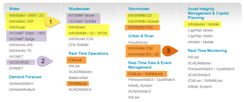
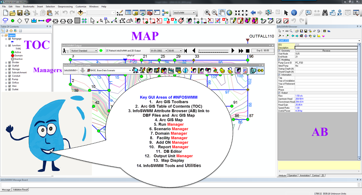
- 1 #INFOSWMM use #ArcGIS , 2 #H2OMAP_SWMM uses #MapInfo, 3 #INFOWORKS_ICM, #SWWMMLive Uses Custom A GUI @Innovyze
- Mini Tweetstorm about @INNOVYZE w/ Many Software Programs and Tools… http://swmm5.org/2016/01/10/mini-tweetstorm-about-innovyze-w-many-software-programs-and-tools-httpwww-innovyze-com-helps-plan-the-future-w-infomaster …
Wednesday, January 13, 2016
Mid January 2016 #INFOSWMM Tweets

 Robert E Dickinson
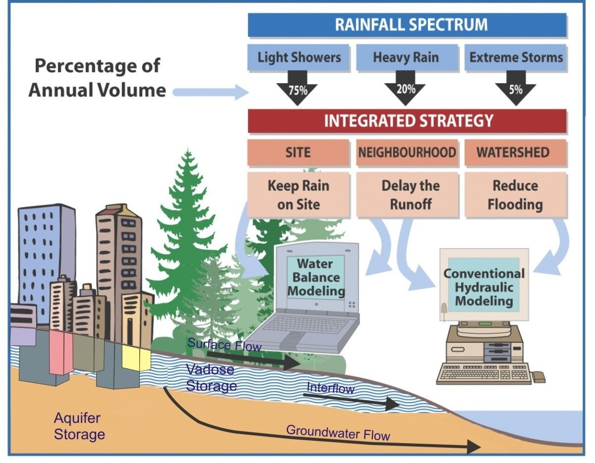
Tuesday, January 12, 2016
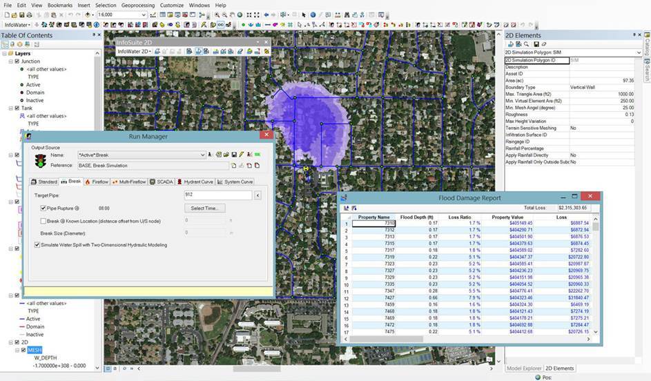
Predict & Assess Impact of Water Spills from Catastrophic Main Breaks Using InfoWater 2D
Predict & Assess Impact of Water Spills from Catastrophic Main Breaks Using InfoWater 2D http://ift.tt/1OYWbaz
Sunday, January 10, 2016
2016 #INFOSWMM Tweets about #HYDROLOGY #CSO #SWMM5
- 1 #INFOSWMM use #ArcGIS , 2 #H2OMAP_SWMM uses #MapInfo, 3 #INFOWORKS_ICM, #SWWMMLive Uses Custom A GUI @Innovyze
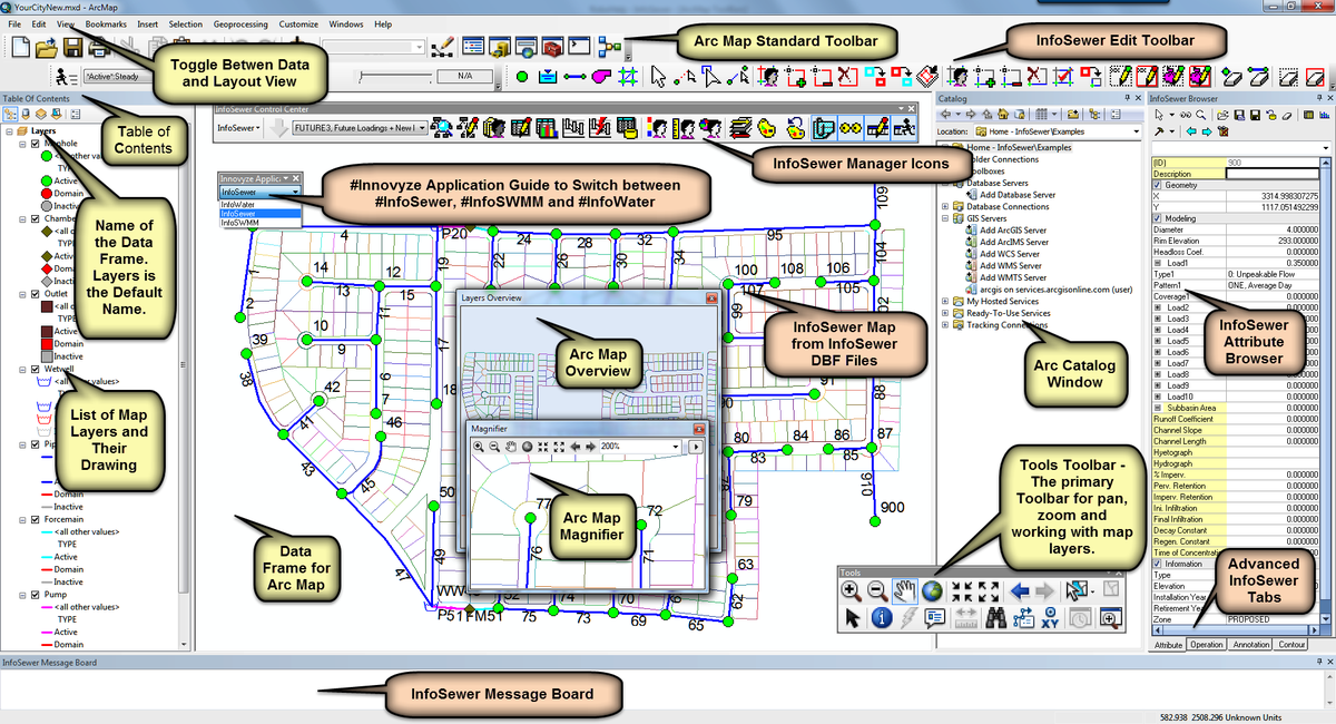
- How #INFOSEWER Maps its DB into #ARCGIS - A Similar Look in #INFOSWMM #iNFOWATER #INFOSURGE and #INFOMASTER
- Continuous Simulation! 1. Precipitation+ 2. Dry+ 3. Hydrology/Hydraulics = 4. #INFOSWMM #INFOWORKS_ICM #rt
- Tweet #1999 from @InnovyzeRobert Many Thanks To All at #INNOVYZE #MONROVIA for PSL Help for #INFOSWMM
- Great feature of the #INFOSWMM and #H2OMapSWMM Help Files is a detailed Applicaation Guide h/t #EPA for H&HwWQ
- We welcome @LimnoTech in DC as our newest @Innovyze #InfoSWMM client...looking forward to helping in their upcoming modeling projects.

 Robert Dickinson
 Peter Martin
Newly updated SuDS Design training - based on CIRIA 2015 SuDS Manual (C753)
Newly updated SuDS Design training - based on CIRIA 2015 SuDS Manual (C753), 26-27 Jan London @Sudsulike http://iz4.me/D02ZUE1
This is a great SuDS - aka as #LID or Low Impact Development in North America
| ||
Many Water Cycle Images that look Great
Water Cycle (Cycle de l'eau - Cycle hydrologique) #STORMWATER #WATER @InnovyzeDavid https://t.co/tDG5FZMUqH pic.twitter.com/8qCMTBKoW0
— Robert Dickinson (@InnovyzeRobert) January 10, 2016
Friday, January 8, 2016
#Innovyze #InfoWater #2D: Predict Impact of #Water Spill from #WaterMain Breaks
#Innovyze #InfoWater #2D: Predict Impact of #Water Spill from #WaterMain Break https://t.co/KNRD0RJDPb #ARCMAP #rt pic.twitter.com/ohhbg5eVSv
— Robert Dickinson (@InnovyzeRobert) January 8, 2016
Wednesday, January 6, 2016
Happy to announce City of Oakland has selected #InfoSWMM Executive Suite to model their sewer collection system
Happy to announce City of Oakland has selected #InfoSWMM Executive Suite to model their sewer collection system pic.twitter.com/fWdC49LxT7
— Innovyze (@Innovyze) January 7, 2016
Tuesday, January 5, 2016
Innovyze Ships InfoWater 2D — Next Generation of Two-Dimensional Modeling of Water Spill from Catastrophic Main Breaks
Innovyze Ships InfoWater 2D — Next Generation of Two-Dimensional Modeling of Water Spill from Catastrophic Main Breaks
First of Its Kind Release Equips Engineers with Unmatched Power to Predict Extent, Duration, Volume and Impact of Water Spill for Rapid, Effective Response Management
Broomfield, Colorado, USA, January 5, 2016
Innovyze, a leading global innovator of business analytics software and technologies for smart wet infrastructure, today announced the worldwide availability of InfoWater 2D, a breakthrough geospatial water distribution network management solution for accurate two-dimensional (2D) above-ground modeling of water spill from main breaks and large leaks, directly within the powerful ArcGIS (Esri, Redlands, CA) environment.
Globally, water demand is rising, aging water infrastructures are rapidly deteriorating, and the impact of water main breaks and leakage is relentless. In the U.S. alone, drinking water systems maintain more than two million miles of distribution mains with about 237,600 water main breaks occurring every year. An estimated seven billion gallons of clean drinking water are wasted every day — a staggering 2.6 trillion gallons annually. Catastrophic water main breaks can result in anywhere from millions to billions of dollars in damages including disastrous litigations.
InfoWater 2D demonstrates Innovyze’s ongoing commitment to delivering pioneering technology that raises the bar for water distribution network modeling and simulation, helping to shape the future of this critical sector. It gives water utilities the flexibility to continue to use the industry-leading and award-winning InfoWater ArcGIS-centric water distribution network modeling solution with added new power to predict the extent, duration, volume and impact of water spill from main breaks and large leaks for rapid, effective response management.
Built atop ArcGIS, InfoWater 2D solves the full range of 2D free-surface shallow water equations using a highly advanced and efficient finite volume method. It gives engineers the unprecedented power to predict and assess potential water spill extent, depth and velocity throughout the flooded area, with results viewable as graphs, tables or animated thematic flood maps. Users can also add parcel maps with property values (cadastral mapping) as well as curves of depth versus property damage to assess the impact of flooding resulting from catastrophic water main breaks. This information is important for insurance-related property valuation, utility liability, and other financial impacts. It is also critical in enabling water utilities and municipalities to proactively identify water mains with the potential for the worst damage and prepare effective emergency response plans.
“InfoWater 2D greatly extends the core features of InfoWater, providing the most powerful and comprehensive ArcGIS-centric tool kit ever for estimating and managing the risks of water main breaks and large leaks,” said Paul F. Boulos, Ph.D., BCEEM, Hon.D.WRE, Dist.D.NE, Dist.MASCE, NAE, President, COO and Chief Technical Officer of Innovyze. “This milestone solution marks a new direction in advanced water distribution systems simulation and analysis. It is the only GIS-centric analysis, design and management software users need to work faster and smarter in a competitive environment — not only to power system performance, but to safeguard critical wet infrastructures and maximize their resiliency and effectiveness in protecting public health. This is the ultimate tool for accurately assessing the impacts of water main breaks and large leaks, then formulating and evaluating sound, cost-effective response strategies. Innovyze is very proud to offer this revolutionary emergency response product to our clients.”
Pricing and Availability
InfoWater 2D for InfoWater is available by subscription worldwide. Special upgrade prices are available for all existing InfoWater users. For the latest information on the Innovyze Subscription Program, including availability and purchase requirements, visit www.innovyze.com or contact your local Innovyze representative.
About InnovyzeInnovyze is a leading global provider of wet infrastructure business analytics software solutions designed to meet the technological needs of water/wastewater utilities, government agencies, and engineering organizations worldwide. Its clients include the majority of the largest UK, Australasian, East Asian and North American cities, foremost utilities on all five continents, and ENR top-rated design firms. With unparalleled expertise and offices in North America, Europe and Asia Pacific, the Innovyze connected portfolio of best-in-class product lines empowers thousands of engineers to competitively plan, manage, design, protect, operate and sustain highly efficient and reliable infrastructure systems, and provides an enduring platform for customer success. For more information, call Innovyze at +1 626-568-6868, or visit www.innovyze.com.
Innovyze Contact:Rajan RayDirector of Marketing and Client Service Manager
Rajan.Ray@innovyze.com
+1 626-568-6868
Subscribe to:
Posts (Atom)