Tuesday, May 23, 2017

AAEES 2017 Innovyze Excellence in Computational Hydraulics/Hydrology Award Presented to Dr. Qian Zhang

AAEES 2017 Innovyze Excellence in Computational Hydraulics/Hydrology Award Presented to Dr. Qian Zhang

Broomfield, Colorado, USA, May 23, 2017 – Innovyze, a leading global innovator of business analytics software and technologies for smart wet infrastructure, today announced that Dr. Qian Zhang, Research Scientist with the University of Maryland Center for Environmental Science at the USEPA Chesapeake Bay Program, has been chosen to receive the American Academy of Environmental Engineers and Scientists (AAEES) 2017 Innovyze Excellence in Computational Hydraulics/Hydrology Award. This prestigious annual award recognizes a student whose research contributes to the knowledge pool in Computational Hydraulics & Hydrology. Selection is based on original, innovative research of publishable quality and other factors. Both Master’s and Ph.D. students are eligible.

Administered by AAEES and co-sponsored by Innovyze, the award consists of cash honoraria of $1,500 for the student and $500 for the major faculty advisor. A $500 travel allotment is also provided to the student recipient to attend the Awards Luncheon. The award selection is administered jointly by a committee consisting of equal members of AAEES and the Association of Environmental Engineering and Science Professors (AEESP).

Dr. Zhang received an M.S. degree in environmental engineering, an M.S. degree in statistics, and a Ph.D. in geography and environmental engineering from Johns Hopkins University. His doctoral research focused on the source, fate, and export of nitrogen, phosphorus, and sediment from the Chesapeake Bay watershed. His areas of research interest include evaluation of long-term river water-quality trends and associated uncertainties; improvement of statistical methods for riverine flux estimation and trend analysis; and analysis of patterns of watershed constituent export and controlling factors.

Dr. Zhang was presented with the award during the AAEES Excellence in Environmental Engineering and Science Annual Awards Luncheon and Conference on April 13 at the National Press Club in Washington, DC.

“I am deeply honored to receive this prestigious award recognizing my work on analysis, modeling and synthesis of large-scale data sets for rivers and watersheds,” said Dr. Zhang. “This award encourages me to continue my research in this mission-critical field, and reminds me that what I do matters.”

“The Innovyze Excellence in Computational Hydraulics/Hydrology Award is the premier award recognizing exceptional research work in the vital field of computational hydraulics and hydrology,” said Michael W. Selna, P.E., BCEE, Past President of AAEES. “Dr. Zhang has demonstrated outstanding academic achievement, exemplary leadership, and a significant commitment to the community at large. We are very pleased to award him this outstanding national recognition, an honor he highly deserves. His research work is very promising and will have a positive impact on our profession.”

“Innovyze is pleased to present this signal award to Dr. Zhang and congratulate him on his impressive work,” said Paul F. Boulos, Ph.D., BCEEM, Hon.D.WRE, Dist.D.NE, Dist.M.ASCE, NAE, Chief Executive Officer of Innovyze. “We are proud to further his future in this critical field and play a small part in his efforts to make the world a better place through his work.”

About Innovyze
Innovyze is a leading global provider of wet infrastructure business analytics software solutions designed to meet the technological needs of water/wastewater utilities, government agencies, and engineering organizations worldwide. Its clients include the majority of the largest UK, Australasian, East Asian and North American cities, foremost utilities on all five continents, and ENR top-rated design firms. Backed by unparalleled expertise and offices in North America, Europe, and Asia Pacific, the Innovyze connected portfolio of best-in-class product lines empowers thousands of engineers to competitively plan, manage, design, protect, operate, and sustain highly efficient and reliable infrastructure systems, and provides an enduring platform for customer success. For more information, call Innovyze at +1 626-568-6868, or visit www.innovyze.com.

Innovyze Contact:
Rajan Ray
Director of Marketing and Client Service Manager
Rajan.Ray@innovyze.com
+1 626-568-6868


Sunday, May 21, 2017

How to approximate the Flood polygon created in InfoSWMM RAM by using Arc Toolbox

How to approximate the Flood polygon created in InfoSWMM RAM by using Arc Toolbox and Subcatchment Manager Tools
Step 1 – Run InfoSWMM and use Map Display to show the Maximum HGL. This is just for reference to the later created polygons.
Step 2 – not needed but as a check to Steps 3 to 5.  Use InfoSWMM RAM to show the area flooding based on the Maximum head or HGL.  This is an approximation of the flooding you would show with have with InfoSWMM 2D.  The maximum HGL is intersected with the DEM or TIN and the DEM elevations below the Maximum HGL are shown in Blue.

Step 3 – Create a contour based on the Maximum HGL in the InfoSWMM run.  Use Contour in the InfoSWMM Browser to create the contour.
Step 4 – The created Contour from the Maximum HGL

Step 5 – Use the Polyline to Raster Arc Toolbox command to make a Raster from the Contour

Step 6 – Optionally you an create a Raster using Convert in the InfoSWMM Subcatchment Manger. The tool creates a DEM from a Contour

Step 7 – Use the CutFill tool in Arc Tool box to find the cut and fill sections of your two Rasters.  The Raster created from the Maximum HGL should be 1st.

Step 8 – The Cut Fill created Raster shows are areas in RED where the RASTER is ABOVE the Maximum HGL and Blue, where the RASTER is Below the Maximum HGL.


Wednesday, May 17, 2017

A new API way of looking at this Blog

A new API way of looking at this Blog

You can click on Get Posts to see the post, Clicking on a label will make a Pop Up Window

http://s3.amazonaws.com/bloggerapi/index.html


Pop Up Window

Tuesday, May 16, 2017

Innovyze and XP Solutions Merge


Innovyze and XP Solutions Merge

The New Innovyze Combines Two of the Most Powerful and Recognizable Names in the Marketplace;
A Winning Combination for the Critical Water and Wastewater Industry

Broomfield, Colorado, USA, May 16, 2017 – Innovyze, a leading global innovator of business analytics software and technologies for smart wet infrastructure, and XP Solutions, a leading provider of software solutions for stormwater/floodwater modeling and drainage design headquartered in Portland, Oregon, announced today that their companies have joined. The expanded company will operate under the Innovyze name going forward. As the new expanded Innovyze, they will be able to offer the most complete wet infrastructure modeling and management solutions and support all technology platforms from workgroup management to AutoCAD-centric, ArcGIS-centric, GIS-based, Web-based, and stand-alone geospatial solutions. Dr. Paul F. Boulos will be Chief Executive Officer of the new combined company and Colby T. Manwaring, P.E. will serve as President.
 
“Joining forces with XP Solutions will help us further enhance our technology innovation and talent pool to even better serve our fast-growing customer base,” said Boulos. “By combining two companies with complementary businesses and a reputation for excellence in the modeling industry, we will be able to provide a broader range of products and services to address the needs of our customers across the spectrum globally. This is an ideal match of culture and technology, and a great win for the critical water and wastewater industry. Our convergence of world-class applications makes us a stronger, even more stable vendor with complementary product attributes; broader, more comprehensive functionality; accelerated innovation delivery; and globally available resources for purchases, support and training. Our customers will have access to an extended partner ecosystem and a broader pool of trained users. They will also have improved access to industry best practices and technical support services across multiple products with lower total deployment, ownership and maintenance costs. Our customer commonality will speed the delivery of those benefits. Because our customers are and will continue to be our best ambassadors, the end result will be more of everything.”

Added Manwaring, “I am genuinely excited about the combination of XP Solutions and Innovyze. This is a tremendous opportunity both to grow the range of our software solutions, and to expand into new geographies with the combined excellence of both companies. We are looking forward to delivering new heights of excellence for our customers, their communities and the environment.”

The combined company will continue to provide customer support and development from its current operations in United Kingdom, the United States, and Australia.
 
About Innovyze
Innovyze is a leading global provider of wet infrastructure business analytics software solutions designed to meet the technological needs of water/wastewater utilities, government agencies, and engineering organizations worldwide. Its clients include the majority of the largest UK, Australasian, East Asian and North American cities, foremost utilities on all five continents, and ENR top-rated design firms. Backed by unparalleled expertise and offices in North America, Europe, and Asia Pacific, the Innovyze connected portfolio of best-in-class product lines empowers thousands of engineers to competitively plan, manage, design, protect, operate, and sustain highly efficient and reliable infrastructure systems, and provides an enduring platform for customer success. For more information, call Innovyze at +1 626-568-6868, or visit www.innovyze.com.
 
About XP Solutions
Established in 1974, XP Solutions is a global provider of industry-standard sustainable drainage design software and stormwater and flood modeling/mapping software for the civil engineering and environmental sectors. Our reliable software technology and professional solutions are used every day around the world by government agencies, engineering companies and environmental management organizations to plan, design, simulate and manage the impact of human interaction with the natural world.  XP Solutions brings over 40 years of experience in developing and supporting professional software systems devoted to improving our use and understanding of water resources, and has expanded its expertise to include a broader scope of designed infrastructure. From designing drainage systems and managing water quality, to mapping flood risk and emergency response and road and site design, our solutions provide our clients with the efficient tools needed to promote safer communities, sustain ecosystems, optimize infrastructure investment, and manage environmental impact. For more information, call +1 888-554-5022 or visit www.xpsolutions.com.
 
Innovyze Contact:
Rajan Ray
Director of Marketing and Client Service Manager
Rajan.Ray@innovyze.com
+1 626-568-6868

Click here if you don't wish to receive these messages in the future or manage your subscriptions here.

Wednesday, May 3, 2017

How to use a Small INI file with the Batch Program of #SWMM5

A great feature of SWMM5 is the ability to use batch files to call the Console engine of SWMM5 or SWMM5.EXE.  This is used by many students and professionals for Monte Carlo and other analysis.  Here is a sample batch file and Figure 1 shows the screen output.

swmm5.exe Example1.inp Example1.rpt Example1.out
swmm5.exe Example2.inp Example2.rpt Example2.out
swmm5.exe Example3.inp Example3.rpt Example3.out
REM RPT is the text output file   
REM OUT is the binary graphics output file
pause

Figure 1 - Windows DOS Batch File Screen

an issue is that once you run the SWMM5.EXE program you cannot see the graphs in the GUI. However, you can make a small ini file as in this 
here is an example of minimum ini file for example1.inp

[SWMM5]
Version=51011
[Results]
Saved=1
Current=1

if you have this ini file then the graph icons are turned on (for example1.inp in Figure 2) but not for Example2.inp (Figure 3) as it did not have an ini file.

Figure 2 - Using a small INI file turns on the Graphics in the SWMM5 GUI.


Figure 3 - If an INI file is not used then the Graph Icons are not turned on in the SWMM5 GUI.


Monday, May 1, 2017

How to Model and Display Peaking Factors in InfoSWMM


How to Model and Display Peaking Factors in InfoSWMM 

A significant difference between InfoSewer/H2OMap Sewer and InfoSWMM/H2OMap SWMM is how peaking factors are applied to the dry weather flow (DWF) at the nodes.  InfoSewer has unspeakable and peakable flow with the peakable flow equation defined in the peaking tab of the Run Manger (Figure 1).  The peakable flow equation is only used in the Steady State solution of InfoSewer. InfoSWMM only has unspeakable flow and no way to define peakable flow.  This blog shows a way to externally calculate the peakable flow in Excel and apply it as a DWF Scenario DB in InfoSWMM/H2OMap SWMM.  Here is a list of steps you can take to show the peakable load in InfoSWMM/H2OMap SWMM.  Figure 12 contrasts the peakable flow estimate in InfoSWMM compared to the InfoSewer peakable steady state flows.
Step 1.  Enter the DWF Unpeakable flow in the InfoSWMM DWF DB table without a DWF Pattern (Figure 2).  We will run the model with constant inflow to simulate the Steady State solution in InfoSewer.
Step 2.  The DWF can also be entered at the node level of the Attribute Browser. Figure 3 shows the DWF loads at the Nodes using lateral flow as the mapping parameter.
Step 3.  Using Run Manager in InfoSWMM run the model using the constant DWF loads.
Step 4.  Find the Total Flow at Each Node using the Customized Report Manager Tool from the model output. We will use the total flow to calculate the peakable flow at each node (Figure 4).
Step 5.  Using the Customized Report Manager Tool find the total flow at each node (Figure 5) by defining the data source as a junction.
Step 6.  Use only the Junction ID and Total Inflow in the Custom Table (Figure 6).
Step 7.  Click Finish to Generate the Report (Figure 7).
Step 8.  Copy the ID and Output Columns to the Clipboard (Figure 8).
Step 9.  Copy the ID and Output Columns to Excel and calculate the Peakable Flow (Figure 9) using the peaking equation  Flow = 2.4 * Unpeakable Flow ^ 0.84.
Step 10.  Copy the ID and Peakable Flow to another Scenario's DWF DB Table.  We call the two scenarios unspeakable and peakable (Figure 10).
Step 11.  You now have a Peakable and Unpeakable DWF Table and Scenario which you can use to Map the peakable and unspeakable flows (Figure 11).
Step 12.  Flows are now Peakable Flows if Mapped as Lateral Inflow (Figure 12).
Step 13.  Figure 13 shows the peakable flows in InfoSewer. They match the Excel calculation tables and the peakable DB table in InfoSWMM.  The peakable flow in InfoSewer is based on the routed unspeakable flows to the node.     
                                                 
Figure 1.  Peaking Factor Equation in InfoSewer/H2OMap Sewer

Figure 2. Constant DWF in InfoSWMM as Unpeakable Flow in the Value Column of the DB Table.
Figure 3.  The DWF can also be entered in the Attribute Browser of InfoSWMM.  Here is map of the DWF lateral flow Nodes.
Figure 4.  We will find the Total Flow at Each Node using the Customized Report Manager Tool.
Figure 5.  Define the Data Source as a Junction.
Figure 6.  Use only the Junction ID and Total Inflow in the Custom Table.

Figure 7.  Click Finish to Generate the Report.

Figure 8.  Copy the ID and Output Columns to the Clipboard.
JUNCTION: ID (Char)
OUTPUT: T_INFLOW (cfs)
Peaked Flow
10309
30
49.52781382
15009
10
18.6299308
16009
30
49.52781382
16109
20
34.52454294
80408
10
18.6299308
80608
20
34.52454294
81009
10
18.6299308
81309
10
18.6299308
82309
20
34.52454294
Figure 9.  Copy the ID and Output Columns to Excel and calculate the Peakable Flow.

Figure 10.  Copy the ID and Peakable Flow to another Scenario’s DWF DB Table.
Figure 11.  You can have a Peakable and Unpeakable DWF Table and Scenario.
Figure 12.  Flows are now Peakable Flows if Mapped as Lateral Inflow.
Figure 13. Peakable flows in InfoSewer at the Links


Sunday, April 23, 2017

Area of a Manhole in #SWMM5

The default area of a manhole is used if the inverts of the connecting links are all above the invert of the node:
1.     Invert of the node to the Invert of the lowest connecting link, the area of the manhole is 1.2 square meters or whatever the user defines,
2.     If the water surface is between the invert of the lowest connecting link and the soffit of the highest connecting link then the area of the node is ½ of the area of the connecting links
3.     If the water surface of the node is above the soffit of the highest connecting link then the area of the node is zero and the program tries to balance the flow into and out of the node so the total flow is zero


Monday, April 17, 2017

Simple SI Unit Model for SWMM5 LID with 100 mm Rainfall - Part 2

This blog is a companion to the blog post https://swmm5.org/2017/04/17/swmm5-simple-100-mm-rainfall-model-for-lid-modeling-part-1/ in which a 1 Hectare model with 100 mm of rainfall had a simple Bio-Retention Cell with no LID outflows.  In part 2 of this blog series we will add a drain coefficient of 10 mm/hr (Figure 1).  The internal pervious area is 0.375 hectares, the nonLID area is 0.75 hectares and the two impervious area are 0.1875 hectares each. The example uses 100 mm of rainfall or precipitation to make the comparisons easier.  The LID Drainage outflow of 27.93 mm (Figure 2) is 6.98 mm over the whole 1 hectare Subcatchment (Figure 3).

The BMP removal is still 100 percent of the SF1 pollutant generation


Figure 1 A 10 mm/hr Drain Coefficient to the LID

Figure 2  The LID now has Drain outflow of 27.84 mm

Figure 3 The LID Drainage outflow of 27.93 mm (Figure 2) is 6.98 mm over the whole 1 hectare Subcatchment


#SWMM5 Simple 100 mm Rainfall model for #LID modeling - Part 1

Simple SI Unit Model for SWMM5 LID with 100 mm Rainfall.
Reading this blog and using the embedded SWMM 5 example file, you will run a simple SI unit model based on factors of 1 and 10. The LID (Bio-Retention Cell) is designed to have zero outflows, Figure 1, as the storage is set to 1000 mm. The Subcatchment area is 1 hectare, the prevent impervious is ½ hectare divided into ¼ hectare sections with and without depression storage, the pervious area is ½ hectare (Figure 2). The LID Bio-Retention area is ¼ hectare or 25 percent of the Subcatchment. The SWMM5 divides the Subcatchment into nonLID and Lid sections (Figure 3) and the impervious area and pervious areas are automatically reduced by the SWMM5 engine (Figure 6). The internal pervious area is 0.375 hectares, the nonLID area is 0.75 hectares and the two impervious area are 0.1875 hectares each. The example uses 100 mm of rainfall or precipitation to make the comparisons easier.
Figure 1 SWMM 5 Bio-Retention Cell Example with settings based on 10 so that no flow leaves the LID.  The Berm and Storage Height are set to 1000 mm.
Figure 2 Power of 10 SI unit example for Subcatchment and LID in SWMM5.  The Subcatchment area is 1 hectare, the prevent impervious is ½ hectare divided into ¼ hectare sections with and without depression storage, the pervious area is ½ hectare
Figure 3 Four types of Runoff Surfaces in SWMM5 with LID's
Figure 4 Subcatchment Summary in SWMM5 - there is no Runoff and all of the Pervious Flow Infiltrates.  The pervious infiltration is 37.5 mm which is the percentage of the 1 Hectare Subcatchment covered by the pervious area.
Figure 5 LID Summary - no flow out of the LID, only storage.  The LID area has initial and final storage - the final storage is the total inflow + the initial storage. The total inflow is 100 mm of rainfall + 37.5 mm of Impervious Runoff / 0.25 Hectares or 150 mm for a total of 250 mm.
Figure 6 Division of 1 Hectare Subcatchment into LID and NonLID Areas.  The internal pervious area is 0.375 hectares, the nonLID area is 0.75 hectares and the two impervious area are 0.1875 hectares each.
[TITLE]
;;Project Title/Notes
LID Model
[OPTIONS]
;;Option Value
FLOW_UNITS CMS
INFILTRATION HORTON
FLOW_ROUTING DYNWAVE
LINK_OFFSETS DEPTH
MIN_SLOPE 0
ALLOW_PONDING YES
SKIP_STEADY_STATE NO
START_DATE 03/22/2017
START_TIME 00:00:00
REPORT_START_DATE 03/22/2017
REPORT_START_TIME 00:00:00
END_DATE 03/23/2017
END_TIME 00:00:00
SWEEP_START 01/01
SWEEP_END 01/03
DRY_DAYS 0
REPORT_STEP 00:05:00
WET_STEP 00:05:00
DRY_STEP 01:00:00
ROUTING_STEP 0:00:05
INERTIAL_DAMPING PARTIAL
NORMAL_FLOW_LIMITED BOTH
FORCE_MAIN_EQUATION H-W
VARIABLE_STEP 0.75
LENGTHENING_STEP 0
MIN_SURFAREA 1.14
MAX_TRIALS 8
HEAD_TOLERANCE 0.0015
SYS_FLOW_TOL 5
LAT_FLOW_TOL 5
MINIMUM_STEP 0.5
THREADS 1
[EVAPORATION]
;;Data Source Parameters
;;-------------- ----------------
CONSTANT 0.0
DRY_ONLY NO
[RAINGAGES]
;;Name Format Interval SCF Source
;;-------------- --------- ------ ------ ----------
1 INTENSITY 0:05 1.0 TIMESERIES A
[SUBCATCHMENTS]
;;Name Rain Gage Outlet Area %Imperv Width %Slope CurbLen SnowPack
;;-------------- ---------------- ---------------- -------- -------- -------- -------- -------- ----------------
; Name Raingage Outlet Area %Imperv Width Slope Clength
100 1 1 1 50 100 1 0.000000
[SUBAREAS]
;;Subcatchment N-Imperv N-Perv S-Imperv S-Perv PctZero RouteTo PctRouted
;;-------------- ---------- ---------- ---------- ---------- ---------- ---------- ----------
100 0.013000 0.050000 0 100 50 OUTLET
[INFILTRATION]
;;Subcatchment MaxRate MinRate Decay DryTime MaxInfil
;;-------------- ---------- ---------- ---------- ---------- ----------
100 50 10 1 999.000000 0.000000
[LID_CONTROLS]
;;Name Type/Layer Parameters
;;-------------- ---------- ----------
Bio-Retention BC
Bio-Retention SURFACE 1000 0.0 0.1 1 5
Bio-Retention SOIL 1000 .5 .25 .10 10 10.0 100
Bio-Retention STORAGE 1000 0.1 0 0
Bio-Retention DRAIN 0 0.5 0 6
[LID_USAGE]
;;Subcatchment LID Process Number Area Width InitSat FromImp ToPerv RptFile DrainTo
;;-------------- ---------------- ------- ---------- ---------- ---------- ---------- ---------- ------------------------ ----------------
100 Bio-Retention 1 2500 10 0 100 0
[JUNCTIONS]
;;Name Elevation MaxDepth InitDepth SurDepth Aponded
;;-------------- ---------- ---------- ---------- ---------- ----------
2 101 4.342740 0.000000 0.000000 0.000000
1 102 7.298640 0.000000 0.000000 80000.000000
[OUTFALLS]
;;Name Elevation Type Stage Data Gated Route To
;;-------------- ---------- ---------- ---------------- -------- ----------------
3 100 FREE NO
[CONDUITS]
;;Name From Node To Node Length Roughness InOffset OutOffset InitFlow MaxFlow
;;-------------- ---------------- ---------------- ---------- ---------- ---------- ---------- ---------- ----------
12 1 2 100 .01 0.000000 0.000000 0.000000 0
23 2 3 100 .01 0.000000 0.000000 0.000000 0
[XSECTIONS]
;;Link Shape Geom1 Geom2 Geom3 Geom4 Barrels Culvert
;;-------------- ------------ ---------------- ---------- ---------- ---------- ---------- ----------
12 CIRCULAR 1 0.000000 0.000000 0.000000 1
23 RECT_CLOSED 1 1.600000 0.000000 0.000000 1
[LOSSES]
;;Link Kentry Kexit Kavg Flap Gate Seepage
;;-------------- ---------- ---------- ---------- ---------- ----------
12 0 0 0.000000 NO 0
23 0 0 0.000000 NO 0
[POLLUTANTS]
;;Name Units Crain Cgw Crdii Kdecay SnowOnly Co-Pollutant Co-Frac Cdwf Cinit
;;-------------- ------ ---------- ---------- ---------- ---------- ---------- ---------------- ---------- ---------- ----------
SF1 MG/L 0 0.0 0.0 0.0 NO * 0.0 0.0 0.0
[LANDUSES]
;; Sweeping Fraction Last
;;Name Interval Available Swept
;;-------------- ---------- ---------- ----------
A 0 0 0
[COVERAGES]
;;Subcatchment Land Use Percent
;;-------------- ---------------- ----------
100 A 100
[LOADINGS]
;;Subcatchment Pollutant Buildup
;;-------------- ---------------- ----------
100 SF1 40
[BUILDUP]
;;Land Use Pollutant Function Coeff1 Coeff2 Coeff3 Per Unit
;;-------------- ---------------- ---------- ---------- ---------- ---------- ----------
A SF1 POW 0.0 1 1 AREA
[WASHOFF]
;;Land Use Pollutant Function Coeff1 Coeff2 SweepRmvl BmpRmvl
;;-------------- ---------------- ---------- ---------- ---------- ---------- ----------
A SF1 EXP 1 1 0.0 0.0
[TIMESERIES]
;;Name Date Time Value
;;-------------- ---------- ---------- ----------
A 00:00 0
A 00:05 9.573452431
A 00:10 10.25274205
A 00:15 11.04623792
A 00:20 11.98563822
A 00:25 13.11546308
A 00:30 14.50019616
A 00:35 16.2367101
A 00:40 18.47713325
A 00:45 21.47391061
A 00:50 25.67639064
A 00:55 31.96236514
A 01:00 42.28290598
A 01:05 61.90323665
A 01:10 110.6596749
A 01:15 202.1863528
A 01:20 122.9825837
A 01:25 78.78745972
A 01:30 57.07434496
A 01:35 44.44627995
A 01:40 36.29030405
A 01:45 30.63131568
A 01:50 26.49481575
A 01:55 23.34912428
A 02:00 20.88150483
A 02:05 18.89679137
A 02:10 17.26739526
A 02:15 15.9065854
A 02:20 14.75345383
A 02:25 13.76406613
A 02:30 12.9059759
A 02:35 12.15470506
A 02:40 11.49147541
A 02:45 10.90163374
A 02:50 10.37359955
A 02:55 9.898093036
A 03:00 9.467598431
[REPORT]
;;Reporting Options
INPUT YES
CONTROLS NO
SUBCATCHMENTS ALL
NODES ALL
LINKS ALL
[TAGS]
[MAP]
DIMENSIONS 82757.219 8542.173 83495.650 8753.113
Units None
[COORDINATES]
;;Node X-Coord Y-Coord
;;-------------- ------------------ ------------------
2 83134.103 8743.516
1 82811.980 8743.508
3 83462.085 8743.524
[VERTICES]
;;Link X-Coord Y-Coord
;;-------------- ------------------ ------------------
[Polygons]
;;Subcatchment X-Coord Y-Coord
;;-------------- ------------------ ------------------
100 83119.103 8710.484
100 83119.103 8551.761
100 82790.784 8551.761
100 82793.138 8710.780
100 82813.136 8730.484
100 83099.103 8730.484
100 83119.103 8710.484
[SYMBOLS]
;;Gage X-Coord Y-Coord
;;-------------- ------------------ ------------------
1 82983.981 8630.926

Friday, April 14, 2017

InfoSWMM SA SWMMLive Manager

InfoSWMM SA SWMMLive Manager is the single utility in InfoSWMM SA to manage all interactions between InfoSWMM SA models and SWMMLive model data exchange. It exports the active InfoSWMM SA scenario as the baseline model to SWMMLive. It allows extension of selected InfoSWMM SA scenarios as additional supporting model data to SWMMLive for scenario switching. It also accepts an exported SWMMLive model for detailed diagnosis run in InfoSWMM SA, supported with all the familiar InfoSWMM SA utilities.

InfoSWMM SA SWMMLive Manager is accessed from the AddOn Extension Manager via its toolbar button or from the Tools menu (Tools - AddOn Extension Manager).
The InfoSWMM SA SWMMLive Manager User Interface is shown below.
The InfoSWMM SA SWMMLive Manager main dialog box has three tabs: Export Model to SWMMLive, Extend Scenario Data to SWMMLive, and Diagnose SWMMLive Model.  All model exchanges between InfoSWMM SA and SWMMLive are made through model definition files with extension inp.
  • Export Model to SWMMLive - Exports the active InfoSWMM SA model for SWMMLive (InfoSWMM SA) to create a baseline model.  All essential information about the active InfoSWMM SA model is exported into the given inp file.  If current InfoSWMM SA model contains scenario data, this option can be used in conjunction with selected scenarios to export scenario-based models with overriding operational scenario data.  All scenario-based model inp files will be exported to their respective scenario sub-folders under the baseline model path.
  • Extend Scenario Data to SWMMLive - Exports additional InfoSWMM SA scenario models based on a provided SWMMLive baseline model.  The operational data from the selected scenarios will be merged into the given SWMMLive reference model to form different scenario models, to be used in SWMMLive.  All scenario-based model inp files will be exported to their respective sub-folders under the given baseline model path.
  • Diagnose SWMMLive Model - Diagnoses a given SWMMLive model using the full utilities available from InfoSWMM SA.  The given SWMMLive model is imported into InfoSWMM SA for any diagnosis analysis in InfoSWMM SA.

Export Model to SWMMLive

In the box of Export Model File to SWMMLive, an inp file is specified for InfoSWMM SA SWMMLive Manager to store the InfoSWMM SA model information.
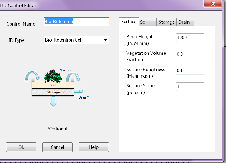
 Browse for a folder location and specify an inp file name.
If the InfoSWMM SA model is blank, SWMMLive Manager will not export.  Otherwise, SWMMLive Manager exports the active scenario as the baseline model to SWMMLive.  

Thursday, April 13, 2017

How can there be more flow in a pipe than its full capacity? #SWMM5 and #InfoSWMM - Emoji View

🌊🌀 Unraveling the Pipe Capacity Enigmas of #SWMM5, ICM InfoWorks & ICM SWMM 🚀🌐

📌 Spotlight on Innovyze: Our enlightening journey today seamlessly blends knowledge from the Innovyze blog, tailored especially for the champions of #SWMM5, ICM InfoWorks, and ICM SWMM! 🔍🔗 Innovyze Blog Post

🤔💡 Puzzling Pipe Phenomenon: Ever had those perplexing moments 🙆‍♂️ when, within #SWMM5 or ICM platforms, a surcharged pipe's maximum simulation flow exceeds its full capacity? Sounds baffling, right? How does more water flow than the pipe's capacity? 🌊🔍

📊 Deciphering Qfull: In #SWMM5 and its ICM counterparts, Qfull (from the link input summary table) is sourced from the revered Manning's equation 📜. While this equation is foundational, it's a tad simpler than the intricate St Venant equations 🧮 harnessed by the engines of SWMM5, ICM InfoWorks, and ICM SWMM for model outputs. This leads to minor variances between Qfull (dictated by slope) and the actual flow discharge as determined by the 1D St Venant Equations. Crucial insight: Qfull serves as a handy reference for us, the users 🧑‍💻, and isn't the engine's yardstick for determining pipe surcharge. 🖥️🔗

🧐 Manning's Equation Unveiled: Manning's equation paints a picture of a pipe that stretches limitlessly 🌌. Resultantly, it's common for a pipe to ferry more water than its nominal capacity sans surcharge. Want a litmus test? 🕵️‍♂️ Extend your pipe or stick to a constant max flow, and voilà, brace yourself for the surcharge spectacle! 🌊🎢

📏✨ The Influence of Length: Pipe length isn't just a number; it's a game-changer! 🚀 A nimble 10-meter pipe might effortlessly channel a flow that its 100-meter sibling grapples with, even if they mirror each other in gradient, roughness, and other traits. It all boils down to friction loss, which magnifies with length! 📈🔥

🎉🎈 Golden Nuggets: As stewards of water 💧 and aficionados of #SWMM5, ICM InfoWorks, and ICM SWMM, it's pivotal to fathom that every modeling marvel, be it SWMM or ICM, amalgamates both time-tested wisdom and sophisticated computations. At times, they might seem at odds, but a deeper dive (literally!) can illuminate and elevate our comprehension! 🌟📚🌍

Stay inquisitive, embrace experimentation, and let's champion the cause of seamless water flow! 🌍🌊🤓🎉🥳🌱🌟🎈📊🌈🚀🌐🔍🔗🌀📜🧮🖥️🧑‍💻🙆‍♂️🕵️‍♂️🎢🚀📏🔥🎊📚🌟🎉🌍🌊🤓🎈🎉🎊🌱🌟🎈📊🌈🚀🌐🔍🔗🌀📜🧮🖥️🧑‍💻🙆‍♂️🕵️‍♂️🎢🚀📏🔥🎊📚🌟🎉🌍🌊🤓🎈🎉🎊🌱🌟🎈📊🌈🚀🌐🔍🔗🌀📜🧮🖥️🧑‍💻🙆‍♂️🕵️‍♂️🎢🚀📏🔥🎊📚🌟🎉🌍🌊🤓🎈🎉🎊🌱🌟🎈📊🌈🚀🌐🔍🔗🌀📜🧮🖥️🧑‍💻🙆‍♂️🕵️‍♂️🎢🚀📏🔥🎊📚🌟🎉🌍🌊🤓🎈🎉🎊🌱🌟🎈📊🌈🚀🌐🔍🔗🌀📜🧮🖥️🧑‍💻🙆‍♂️🕵️‍♂️🎢🚀📏🔥🎊📚🌟🎉🌍🌊🤓🎈🎉🎊🌱🌟🎈📊🌈🚀🌐🔍🔗🌀📜🧮🖥️🧑‍💻🙆‍♂️🕵️‍♂️🎢🚀📏🔥🎊📚🌟🎉🌍🌊🤓🎈🎉🎊🌱🌟🎈📊🌈🚀🌐🔍🔗🌀📜🧮🖥️🧑‍💻🙆‍♂️🕵️‍♂️🎢🚀📏🔥🎊📚🌟🎉🌍🌊🤓🎈🎉🎊🌱🌟🎈📊🌈🚀🌐🔍🔗🌀📜🧮🖥️🧑‍💻🙆‍♂️

The Goal of SWMM5 Input Files

 🌟 SWMM5 (Storm Water Management Model 5) is a widely used urban hydrology and hydraulic modeling software developed by the United States E...