Saturday, February 7, 2015

InfoSWMM and H20Map SWMM and their Relationship to FEMA Approved SWMM 5 Engines

The purpose of this note is to show how InfoSWMM is related to various SWMM 5 engines. InfoSWMM is a ESRI Arc Map Interface to the properties of the SWMM 5 engine using model development tools created by Innovyze for InfoWater and InfoSewer. It uses a recompiled SWMM 5 engine for the purposes of integration with Arc GIS but the underlying engine code is the EPA SWWM 5 code. InfoSWMM has very good import and export tools for reading and writing SWMM 5 files. InfoSWMM does not have to be on the official FEMA list as it uses and exports the FEMA approved current SWMM 5 engine.
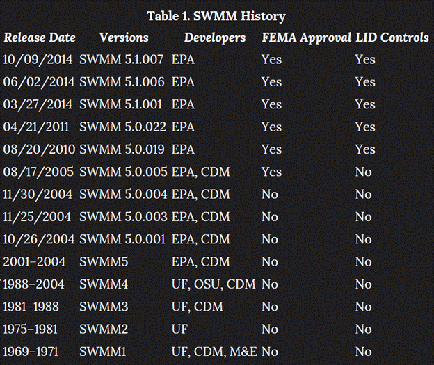
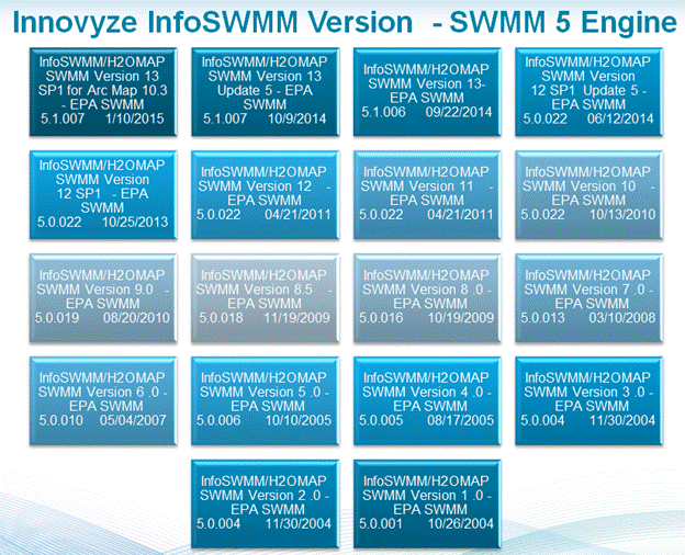
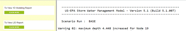
SWMM 5 has been approved by FEMA since 2005. Figure 1 shows the versions of SWMM that have been approved by FEMA. It is approval that continues each time a new EPA SWMM 5 is released. Innovyze InfoSWMM and H2OMap SWMM use a recompiled SWMM 5 engine based on the current version of EPA SWMM (Figure 2). The match between the EPA Engine and InfoSWMM is shown in Figure 2. EPA SWMM 5.x was produced by the Water Supply and Water Resources Division of the U.S. Environmental Protection Agency's National Risk Management Research Laboratory with assistance from the consulting firm of CDM Inc under a Cooperative Research and Development Agreement (CRADA) in 2004. Innovyze released the first version of InfoSWMM at the same time and keeps up to date with the latest SWMM 5 releases. The EPA SWMM 5 version used in the current version of InfoSWMM is listed at the top of the text output file (Figure 3).
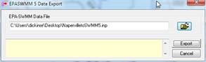
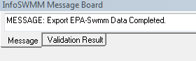
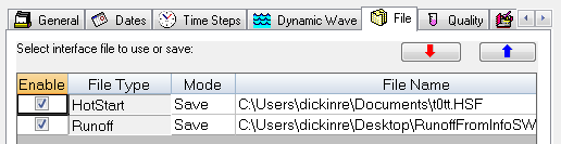
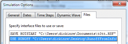
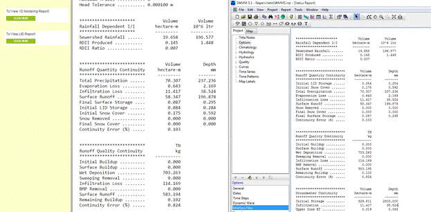
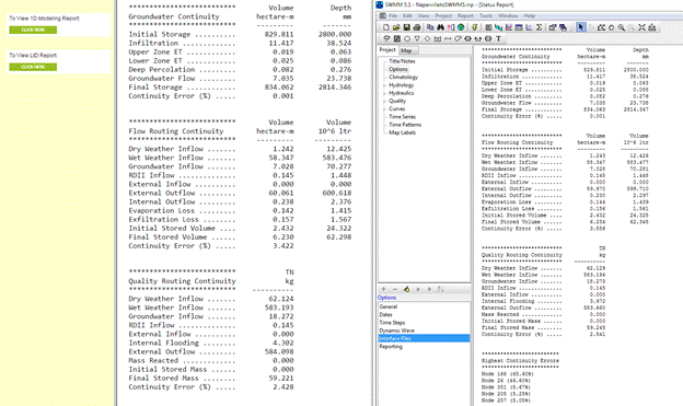
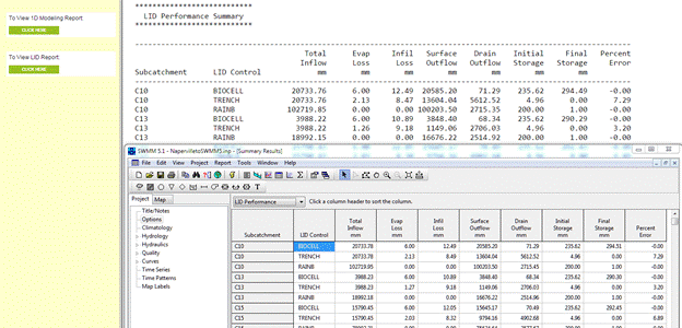
We will show in the rest of this note how you compare the InfoSWMM engine results to the EPA SWMM 5 engine results. There are many processes to compare: RDII, Runoff, Groundwater, Snowmelt, Quality, Routing (Figure 4). The InfoSWMM model is exported to SWMM 5 (Figure 5) with the message board showing any problems in the export (Figure 6). The exported file can be immediately imported into SWMM 5 (Figure 7). Any files created by InfoSWMM such as RDII, Runoff or Hot Start files have the same format as SWMM 5 and can be used immediately in SWMM5 (Figure 8 and Figure 9). The process flows are the same in InfoSWMM and SWMM 5 (Figure’s 10, 11 and 12) as the underlying engine is the same (Figure 13) for the compared model (see Figure 14 for a comparison view of InfoSWMM and SWMM 5).
clip_image002
Figure 1. Time History of FEMA and SWMM Versions
clip_image004
Figure 2 InfoSWMM Versions and Corresponding EPA SWMM 5 Engines
clip_image006
Figure 3 The Version of the SWMM 5 Engine Used in InfoSWMM is shown at the top of the Text Output File.
clip_image008
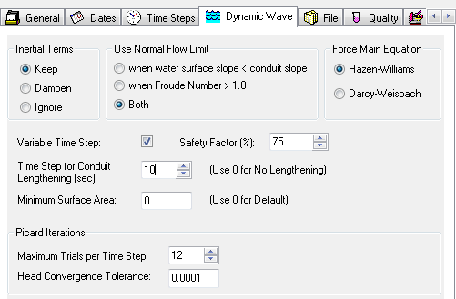
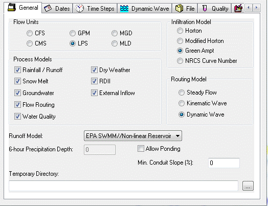
Figure 4. The SWMM 5 Engine has many Processes as shown in this InfoSWMM Dialog.
clip_image010
Figure 5. The export of an InfoSWMM Model to a SWMM 5 Inp file is a One Step Command
clip_image012
Figure 6. The InfoSWMM Message Board shows Any Export Messages.
clip_image014
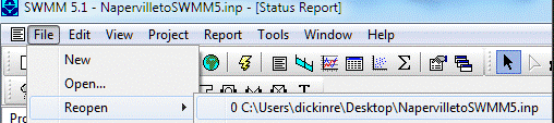
Figure 7. The import of the Exported InfoSWMM File into SWMM 5 is also a One Step Command
clip_image016
Figure 8. All Files Created in InfoSWMM can be used directly in SWMM 5 - it has to be the proper SWMM 5 engine corresponding to the InfoSWMM Version.
clip_image018
Figure 9. All Files Created in InfoSWMM can be used directly in SWMM 5. This is the SWMM 5 dialog that is equivlennt to the InfoSWMM Dialog.
clip_image020
Figure 10. RDII, Runoff and Water Quality compared in the InfoSWMM Output (left) and SWMM 5 Output (right). The Process Values are the same.
clip_image022
Figure 11 Groundwater, Flow and Water Quality Routing compared in the InfoSWMM Output (left) and SWMM 5 Output (right). The Process Values are the same.
clip_image024
Figure 12 LID Process Components compared in the InfoSWMM Output top) and SWMM 5 Output (bottom). The Process Values are the same.
clip_image026
Figure 13. InfoSWMM uses the SWMM 5 C code for the Current Version of EPA SWMM in a Recompiled C++ Shell.
clip_image028
Figure 14. The Model discussed here has 232 Links. InfoSWMM (left) and SWMM 5 (right).

Sunday, February 1, 2015

WikiLand View of the SWMM5 Wikipedia Article

Wikiland View of the SWMM5 Wikipedia Article   https://en.wikipedia.org/wiki/Storm_Water_Management_Model


https://en.wikipedia.org/wiki/Storm_Water_Management_Model

Tuesday, January 27, 2015

Innovyze President Paul Boulos to Discuss Smart Water Networks at Government Accountability Office Municipal Water Technologies Expert Meeting

Innovyze Press Release
 Insider BlogLinkedInTwitterYouTubeYouTube
Innovyze President Paul Boulos to Discuss Smart Water Networks at Government Accountability Office Municipal Water Technologies Expert Meeting
Leading Industry Experts to Assist GAO in Preparing Municipal Water Technologies Report
Broomfield, Colorado, USA, January 27, 2015 — Innovyze, a leading global innovator of business analytics software and technologies for smart wet infrastructure, today announced that its president, COO and chief technical officer, Paul F. Boulos, Ph.D., BCEEM, NAE, Hon.D.WRE, Dist.D.NE, F.ASCE, will address a staff workshop at the Government Accountability Office (GAO) as the GAO prepares a congressionally requested report on municipal water technologies.

At the workshop, slated January 29-30, 2015, in Washington, D.C., more than 20 leading water experts will convene with the GAO to address water scarcity in the U.S., discussing the state of the art in a wide range of municipal water supply and technology topics. They include making more efficient use of the nation’s current freshwater resources through system operations and conservation technologies; augmenting current resources through water treatment, desalination, and reuse technologies; and factors affecting implementation of such approaches (including tradeoffs between technologies, tradeoffs between technology-based solutions and other (non-tech) ways of achieving efficiencies, and regional considerations). Dr. Boulos’ presentation will focus on leveraging smart water networks to transform the water industry, helping to optimize water utility management, reduce inefficiencies, ensure infrastructure sustainability and resilience, and improve drought management and customer service.

Dr. Boulos is one of the world’s foremost experts on water resources and navigation engineering and the author of nine authoritative books and more than 200 technical articles on issues critical to the water and wastewater industry. He has received numerous honors from national and international scientific and engineering societies, governments, universities, and NGOs, including technical awards for excellence in scholarship from the American Society of Civil Engineers (ASCE), the American Water Works Association and the U.S. Environmental Protection Agency. He was recognized with the U.S. Ellis Island Medal of Honor, one of America’s highest accolades; the Pride of Heritage Award from the Lebanese American Foundation; and the Lebanese American University Alumni of the Year Award. He is a member of the University of Kentucky College of Engineering Hall of Distinction, the highest honor the university bestows on its alumni.

Dr. Boulos has been awarded Honorary Diplomate status by the American Academy of Water Resources Engineers and Distinguished Diplomate status in Navigation Engineering by the Academy of Coastal, Ocean, Port & Navigation Engineers, the top honors for both academies. He is a Fellow of ASCE, a Diplomate (by Eminence) of the American Academy of Environmental Engineers and Scientists, and a member of the National Academy of Engineering (NAE), the highest professional distinction accorded to an engineer.
About Innovyze
Innovyze is a leading global provider of wet infrastructure business analytics software solutions designed to meet the technological needs of water and wastewater utilities, government agencies, and engineering organizations worldwide. Its clients include the majority of the largest UK, Australasia and North American cities, foremost utilities on all five continents, and ENR top-rated design firms. With unparalleled expertise and offices in North America, Europe, and Asia Pacific, the Innovyze connected portfolio of best-in-class product lines empowers thousands of engineers to competitively plan, manage, design, protect, operate and sustain highly efficient and reliable infrastructure systems, and provides an enduring platform for customer success. For more information, call Innovyze at +1 626-568-6868, or visit www.innovyze.com.
Innovyze Contact
Timothy Gallagher, P.E., PMP
Executive Action Officer

Saturday, January 10, 2015

Create Watershed Data Using the InfoSWMM Subcatchment Manager

Subject:  Create Watershed Data Using  the InfoSWMM Subcatchment Manager

The Subcatchment Manager of InfoSWMM will  help calculate most of the  physical parameters associated with a Watershed or Subcatchment in SWMM 5 from a Digital Elevation Data (Step 1).  The Subcatchments slope is estimated from a slope raster (Step 2) and the Slope Calculator (Step 4). The created watershed area are calculated using the command Update DB from Map (Step 6) along with the Subcatchment Width (Step 3) and the Impervious Area (Step 5).   The physical parameters estimated from the DEM are shown in Figure 1.
Step 1.  Use the command Create Flow Stream to create a Flow Stream for the DTM or DEM that can be used later.
Step 2.   Create a Slope Raster from the DEM for later usage in the Slope Calculator.
Step 6.   Use Arc Map to calculate the area of the Subcatchments using the command Update DB from Map and the following Operation Flags.

New @InnovyzeRobert Twitter Account as a Companion Account to @RDICKINSON

Tuesday, January 6, 2015

Innovyze Unveils InfoSWMM Sustain for Comprehensive Urban Stormwater Treatment and Analysis

Innovyze Press Release
 Insider BlogLinkedInTwitterYouTubeYouTube
Innovyze Unveils InfoSWMM Sustain for Comprehensive Urban Stormwater Treatment and Analysis
New Software Lets Stormwater Management Professionals Determine Optimal BMP Combinations at Various Watershed Scales Based on Cost and Effectiveness
Broomfield, Colorado, USA, January 6, 2014 — Innovyze, a leading global innovator of business analytics software and technologies for smart wet infrastructure, today announced the second quarter 2015 release ofInfoSWMM Sustain. Designed in response to the needs of watershed and stormwater engineering professionals, this power tool lets users develop, evaluate, and select optimal best management practice (BMP) combinations at various watershed scales on the basis of cost and effectiveness.

InfoSWMM Sustain is a comprehensive geocentric decision support system created to facilitate optimal selection and placement of BMPs and low impact development (LID) techniques at strategic locations in urban watersheds. It can accurately model any combination of LID controls, such as porous permeable pavement, rain gardens, green roofs, street planters, rain barrels, infiltration trenches, and vegetative swales, to determine their effectiveness in managing stormwater and combined sewer overflows. Such capabilities can greatly assist users in developing cost-effective and reliable implementation plans for flow and pollution control aimed at protecting source waters and meeting water quality goals. It does so by helping users answer the following questions: How effective are BMPs in reducing runoff and pollutant loadings? What are the most cost-effective solutions for meeting water quality and quantity objectives? And where, what type, and how extensive should BMPs be?

By seamlessly integrating ArcGIS 10.x with SWMM 5.1, InfoSWMM Sustain greatly expands on the USEPA SUSTAIN software to provide critically needed support to watershed practitioners at all levels in developing stormwater management evaluations and cost optimizations to meet their program needs. The software can automatically import any SWMM5.1, InfoSWMM or InfoWorks ICM model, then evaluate numerous potential combinations of BMPs to determine the optimal combination to meet specified objectives such as runoff volume or pollutant loading reductions. Both kinematic wave and full dynamic wave flow routing models are fully supported. Among its many vital applications, InfoSWMM Sustain can be effectively used in developing TMDL implementation plans, identifying management practices to achieve pollutant reductions under a separate municipal storm sewer system (MS4) stormwater permit, determining optimal green infrastructure strategies for reducing volume and peak flows to combined sewer systems, evaluating the benefits of distributed green infrastructure implementation on water quantity and quality in urban streams, and developing a phased BMP installation plan using cost effectiveness curves.

“With InfoSWMM Sustain, we are extending our success in the smart network modeling marketplace to address the specific needs of stormwater management professionals and their engineering consultants,” said Paul F. Boulos, Ph.D., BCEEM, NAE, Hon.D.WRE, Dist.D.NE, F.ASCE, President, COO and Chief Technical Officer of Innovyze. “It performs sophisticated hydrologic and water quality modeling in watersheds and urban streams, and enables users to determine optimal management solutions at multiple-scale watersheds to achieve desired water quality objectives based on cost effectiveness. It also gives users the power tool they need to maximize water quality benefits, minimize stormwater management costs and combined sewer overflows, and protect the environment and public health.”
About Innovyze
Innovyze is a leading global provider of wet infrastructure business analytics software solutions designed to meet the technological needs of water and wastewater utilities, government agencies, and engineering organizations worldwide. Its clients include the majority of the largest UK, Australasia and North American cities, foremost utilities on all five continents, and ENR top-rated design firms. With unparalleled expertise and offices in North America, Europe, and Asia Pacific, the Innovyze connected portfolio of best-in-class product lines empowers thousands of engineers to competitively plan, manage, design, protect, operate and sustain highly efficient and reliable infrastructure systems, and provides an enduring platform for customer success. For more information, call Innovyze at +1 626-568-6868, or visit www.innovyze.com.

Saturday, January 3, 2015

How does Conduit Lengthening Work in SWMM5 via Twitter

1/1. How does Conduit Lengthening Work in SWMM5?
1/2. A new length conduit with a lower Manning's N 1/3. The Flow and Velocity are the Same

2/1. How does Conduit Lengthening Work in SWMM5?
2/2. Check the sum of the new Lengths in the Flow Table
2/3 Check the Sum of the New Length - it will give you an understanding of the New Volume in the Model. You do not want to have a large increase in volume, plus longer lengths reduce the slope of the links which may cause problems.

3/1 Check the Sum of the New Length - A surrogate for the New Volume 3/2 You do not want a large increase in Volume 3/3 SWMM5 / InfoSWMM

Thursday, January 1, 2015

3D and 2D Bar graphs of the Process components in InfoSWMM

The new InfoSWMM and H2OMap SWMM v13  graphics allow you to easily make 3D and 2D Bar graphs of the Process components in the model.  The possible processes and the output of the processes can be seen in the Routing Continuity Output Table (Figure 1).  You can make both 3D Bar Graphs (Figure 2) and 2D Bar Graphs (Figure 3) from the data an any other tabular data.

Figure 1. Continuity Flow Routing Output Table (right mouse click to see graphics options)

Figure 2.  Log Scale with 3D Bar Graphs using the Continuity Flow Routing Output Table.

Figure 3.  Log Scale with 2D Bar Graphs using the Continuity Flow Routing Output Table.
You can also make these Bar Graphs with the the Summary Tables (Figure 4).

Figure 4.  2D Bar Graphs for the Storage Summary Table.

The Goal of SWMM5 Input Files

 ðŸŒŸ SWMM5 (Storm Water Management Model 5) is a widely used urban hydrology and hydraulic modeling software developed by the United States E...